
Fichye:Iron Curtain map.svg

Taille de cet aperçu PNG pour ce fichier SVG : 560 × 599 piksèl. Lòt rezolisyon yo: 224 × 240 piksèl | 449 × 480 piksèl | 718 × 768 piksèl | 957 × 1 024 piksèl | 1 914 × 2 048 piksèl | 645 × 690 piksèl.
Fichye orijinal (Fichye SVG, rezolisyon de 645 × 690 piksèl, gwosè fichye : 322 kio)
Rezime
| Deskripsyon |
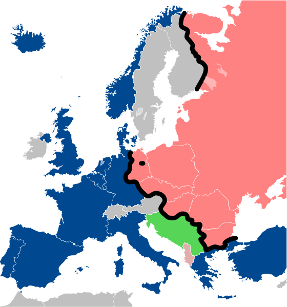
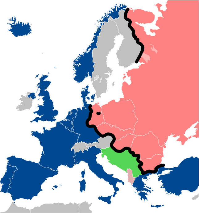
Lëtzebuergesch: Kaart vum Westen an dem Ostblock an Europa während dem Kale Krich.
"Eise Rido"
Neutral Länner
|
||
| Dat | |||
| Sous |
Travail personnel (own work). Sources:
|
||
| Kreyatè | Sémhur | ||
| Autres versions |
File:Iron Curtain map alternative.svg (Same, but with Yugoslavia on the Eastern side of the Iron Curtain.) | ||
| Rekonèt avèk non otè (imposé par la licence) | © Sémhur / Wikimedia Commons / | ||
| SVG | W3C-validity not checked. Cette image vectorielle non W3C-spécifiée a été créée avec Inkscape .
|
||
| Graphic Lab |

| Lieu de la prise de vue | | Voir cet endroit et d’autres images sur : OpenStreetMap |
|---|
Kondisyon itlizasyon
Moi, en tant que détenteur des droits d’auteur sur cette œuvre, je la publie sous les licences suivantes :
| Copyleft : cette œuvre d’art est libre ; vous pouvez la redistribuer ou la modifier selon les termes de la licence Art Libre. Vous trouverez un exemplaire de cette licence sur le site Copyleft Attitude ainsi que sur d’autres sites. |
This file is licensed under the Creative Commons Attribution-Share Alike 4.0 International, 3.0 Unported, 2.5 Generic, 2.0 Generic and 1.0 Generic license.
- Ou gen dwa:
- pou pataje – pou kopye, distribiye epi difize ouvraj la
- pou remiks – pou adapte ouvraj la
- Selon kondisyon sa a yo:
- Rekonèt avèk non otè – Ou dwe bay enfòmasyon apwopriye sou otè a, bay yon lyen pou lisans lan, epi endike si te gen chanjman ki fèt. Ou ka fè sa nan nenpòt fason rezonab, men okenn fason ki sijere ke otè a soutni oswa apwouve itilizasyon ou an.
- Enfòmasyon sa yo ka pataje – Si ou fè rekopye, transfòme, oswa baze sou materyèl sa, ou dwe distribye kontribisyon ou anba menm oswa yon lisans konpatib avèk orijinal la.
Chwazi lisans ou vle a.
Istorik fichye a
Klike sou yon dat/yon lè pou wè fichye a jan li te ye nan moman sa a.
| Dat ak lè | Minyati | Grandè yo | Itilizatè | Komantè | |
|---|---|---|---|---|---|
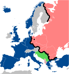
| Kounye a | 15 desanm 2022 à 13:26 | | 645 × 690 (322 kio) | PhotographyEdits | Extend the Iron Curtain eastwards of Yugoslavia. Even though Yugoslavia was not really considered part of the West, the currenet map gives the false impression that there was a huge gap in the Iron Curtain, which wasn't the case. |
| 23 jiyè 2022 à 00:56 |  | 645 × 690 (321 kio) | Kwamikagami | NATO blue, #004990 | |
| 30 mas 2019 à 20:30 |  | 645 × 690 (321 kio) | Sémhur | Reverted to version as of 07:07, 27 May 2014 (UTC). Albania leaves the Waras Pack in middle of cold war; this is why it's shown wtih stripes. | |
| 24 mas 2019 à 09:18 |  | 512 × 548 (123 kio) | Hakuli | Albania leaves the Waras Pack in middle of cold war | |
| 27 me 2014 à 07:07 |  | 645 × 690 (321 kio) | Sémhur | Valid SVG | |
| 16 novanm 2010 à 13:51 |  | 645 × 690 (321 kio) | Sémhur | Added Iron Curtain between Bulgaria and Greece & Turkey. | |
| 27 septanm 2008 à 16:57 |  | 645 × 690 (321 kio) | Sémhur | Correcting mistake : Austria wasn't in NATO. | |
| 31 me 2008 à 10:51 |  | 645 × 690 (330 kio) | Sémhur | {{Information |Description={{en|1=Map of the Iron Curtain in Europe.}} {{fr|1=Carte du rideau de fer en Europe.}} {{es|1=Mapa del Telón de Acero en Europa.}} |Source=Travail personnel (ow |
Itilizasyon fichye sa a
Itilizasyon global fichye a
Wiki sa a yo sèvi ak fichye sa a:
- Itilizasyon sou af.wikipedia.org
- Itilizasyon sou als.wikipedia.org
- Itilizasyon sou ar.wikipedia.org
- Itilizasyon sou ast.wikipedia.org
- Itilizasyon sou azb.wikipedia.org
- Itilizasyon sou az.wikipedia.org
- Itilizasyon sou ba.wikipedia.org
- Itilizasyon sou be-tarask.wikipedia.org
- Itilizasyon sou be.wikipedia.org
- Itilizasyon sou bg.wikipedia.org
- Itilizasyon sou br.wikipedia.org
- Itilizasyon sou bs.wikipedia.org
- Itilizasyon sou ca.wikipedia.org
- Itilizasyon sou cs.wikipedia.org
- Itilizasyon sou cy.wikipedia.org
- Itilizasyon sou da.wikipedia.org
- Itilizasyon sou de.wikipedia.org
- Itilizasyon sou el.wikipedia.org
- Itilizasyon sou el.wiktionary.org
- Itilizasyon sou en.wikipedia.org
- Itilizasyon sou en.wikibooks.org
- Itilizasyon sou en.wikiquote.org
- Itilizasyon sou en.wiktionary.org
Gade plis itilizasyon global fichye sa a.