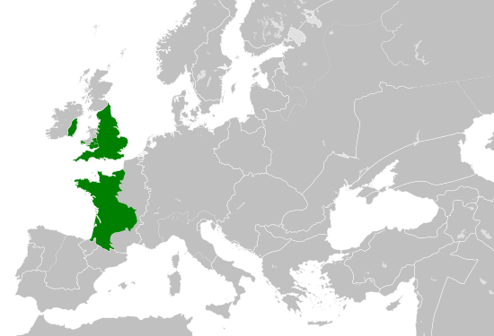
Fichye:Angevin Empire 1190.svg

Fichye orijinal (Fichye SVG, rezolisyon de 550 × 375 piksèl, gwosè fichye : 998 kio)
Fichye sa a sòti nan Wikimedia Commons e ka sèvi nan lòt pwojè. Desktripsyon ki sou paj li file description page ekri anba a.
Rezime
Kondisyon itlizasyon
- Ou gen dwa:
- pou pataje – pou kopye, distribiye epi difize ouvraj la
- pou remiks – pou adapte ouvraj la
- Selon kondisyon sa a yo:
- Rekonèt avèk non otè – Ou dwe bay enfòmasyon apwopriye sou otè a, bay yon lyen pou lisans lan, epi endike si te gen chanjman ki fèt. Ou ka fè sa nan nenpòt fason rezonab, men okenn fason ki sijere ke otè a soutni oswa apwouve itilizasyon ou an.
- Enfòmasyon sa yo ka pataje – Si ou fè rekopye, transfòme, oswa baze sou materyèl sa, ou dwe distribye kontribisyon ou anba menm oswa yon lisans konpatib avèk orijinal la.
Légendes
Éléments décrits dans ce fichier
dépeint français
statut des droits d'auteur français
sous droit d'auteur français
date de fondation ou de création français
29 me 2016
type MIME français
image/svg+xml
somme de contrôle français
d8c7ca8cfb54369a17a4415012dbfe7a170f19e2
taille des données français
1 022 039 octet
375 pixel
largeur français
550 pixel
Istorik fichye a
Klike sou yon dat/yon lè pou wè fichye a jan li te ye nan moman sa a.
| Dat ak lè | Minyati | Grandè yo | Itilizatè | Komantè | |
|---|---|---|---|---|---|
| Kounye a | 29 me 2016 à 16:06 |  | 550 × 375 (998 kio) | Alphathon | == {{int:filedesc}} == {{Inkscape}} {{Information |Description={{en|A map of the so-called en:Angevin Empire within Europe circa 1190 CE. Note that the borders of the Cumans, Kipchaks, Kievan Rus', Kama Bulgarians and Viatka do not extend r... |
Itilizasyon fichye sa a
Pa gen okenn paj ki itilize dosye sa a.
Itilizasyon global fichye a
Wiki sa a yo sèvi ak fichye sa a:
- Itilizasyon sou arz.wikipedia.org
- Itilizasyon sou ca.wikipedia.org
- Itilizasyon sou cs.wikipedia.org
- Itilizasyon sou da.wikipedia.org
- Itilizasyon sou el.wikipedia.org
- Itilizasyon sou en.wikipedia.org
- Itilizasyon sou es.wikipedia.org
- Itilizasyon sou fa.wikipedia.org
- Itilizasyon sou fr.wikipedia.org
- Itilizasyon sou ga.wikipedia.org
- Itilizasyon sou gl.wikipedia.org
- Itilizasyon sou he.wikipedia.org
- Itilizasyon sou hr.wikipedia.org
- Itilizasyon sou id.wikipedia.org
- Itilizasyon sou it.wikipedia.org
- Itilizasyon sou ko.wikipedia.org
- Itilizasyon sou sk.wikipedia.org
- Itilizasyon sou tr.wikipedia.org
- Itilizasyon sou uk.wikipedia.org
- Itilizasyon sou www.wikidata.org
Metadone
Fichye sa genyen enfòmasyon adisyonèl, petèt ki soti nan yon kamera dijital oubyen yon nimerizè itilize pou kreye oubyen dijitalize li. Si fichye sa te modifye depi kreyasyon li, kèk detay ka pa menm avèk original la.
| Titre court | Angevin Empire circa 1190 CE |
|---|---|
| Titre de l’image | A map of the Angevin Empire within Europe circa 1190 CE.
Note that the borders of the Cumans, Kipchaks, Kievan Rus', Kama Bulgarians and Viatka do not extend right to the edge of the map (due to a sub-map covering them up on the source map). Similarly, Ireland was not united but was in fact composed of many petty kingdoms Released under CreativeCommons Attribution-ShareAlike 4.0 (CC BY-SA 4.0; https://creativecommons.org/licenses/by-sa/4.0/) by Wikimedia Commons user Alphathon (https://commons.wikimedia.org/wiki/User:Alphathon) The map is based on https://commons.wikimedia.org/wiki/File:Blank_map_of_Europe.svg. The metadata description for that file is contained at the end of this file's metadata description. Most of the data is derived from a map created by William Robert Shepherd, which is now in the public domain. The source scan can be found at https://commons.wikimedia.org/wiki/File:Europe_mediterranean_1190.jpg Metadata from https://commons.wikimedia.org/wiki/File:Blank_map_of_Europe.svg : A blank map of Europe. Every country has an id which is its ISO-3166-1-ALPHA2 code in lower case. Members of the EU have a class="eu", countries in europe (which I found turkey to be but russia not) have a class="europe". Certain countries are further subdivided the United Kingdom has gb-gbn for Great Britain and gb-nir for Northern Ireland. Russia is divided into ru-kgd for the Kaliningrad Oblast and ru-main for the Main body of Russia. There is the additional grouping #xb for the "British Islands" (the UK with its Crown Dependencies - Jersey, Guernsey and the Isle of Man) and the Kingdom of Denmark (Denmark, Faroe Islands, Greenland) Contributors. Original Image: (http://commons.wikimedia.org/wiki/Image:Europe_countries.svg) Júlio Reis (http://commons.wikimedia.org/wiki/User:Tintazul). Recolouring and tagging with country codes: Marian "maix" Sigler (http://commons.wikimedia.org/wiki/User:Maix) Improved geographical features: http://commons.wikimedia.org/wiki/User:W!B: Updated to reflect dissolution of Serbia & Montenegro: http://commons.wikimedia.org/wiki/User:Zirland Updated to include British Crown Dependencies as seperate entities and regroup them as "British Islands", with some simplifications to the XML and CSS: James Hardy (http://commons.wikimedia.org/wiki/User:MrWeeble) Validated (http://commons.wikimedia.org/wiki/User:CarolSpears) Changed the country code of Serbia to RS per http://en.wikipedia.org/wiki/Serbian_country_codes and the file http://www.iso.org/iso/iso3166_en_code_lists.txt (http://commons.wikimedia.org/wiki/User:TimothyBourke) Uploaded on behalf of User:Checkit, direct complaints to him plox: 'Moved countries out of the "outlines" group, removed "outlines" style class, remove separate style information for Russia' (http://commons.wikimedia.org/wiki/User:Collard) Updated various coastlines and boarders and added various islands not previously shown (details follow). Added Kosovo, Northern Cyprus, Crimea, Abkhazia, South Ossetia, Transnistria and Nagorno-Karabakh as disputed territories. Moved major lakes to their own object and added more. List of updated boarders/coastlines: British Isles (+ added Isle of Wight, Skye, various smaller islands), the Netherlands, Germany, Austria, Hungary, Czech Republic, Denmark, Sweden, Finland, Poland, Kaliningrad Oblast of the Russian Federation (and minor tweaks to Lithuania), Estonia, Ukraine, Moldova (minor), Romania, Bulgaria, Turkey, Greece, F.Y.R. Macedonia, Serbia, Bosnia and Herzegovina, Montenegro, Albania, Croatia, Italy (mainland and Sicily), Malta (http://commons.wikimedia.org/wiki/User:Alphathon). Added Bornholm (http://commons.wikimedia.org/wiki/User:Heb)Released under CreativeCommons Attribution ShareAlike (http://creativecommons.org/licenses/by-sa/2.5/). |
| Largeur | 550 |
| Hauteur | 375 |


