
Fichye:16-07-06-Rathaus Graz Turmblick-RR2 0275.jpg
Fichye orijinal (4 288 × 2 848 piksèl, gwosè fichye a : 9,76 Mio, tip MIME li ye : image/jpeg)
Rezime
| Deskripsyon |
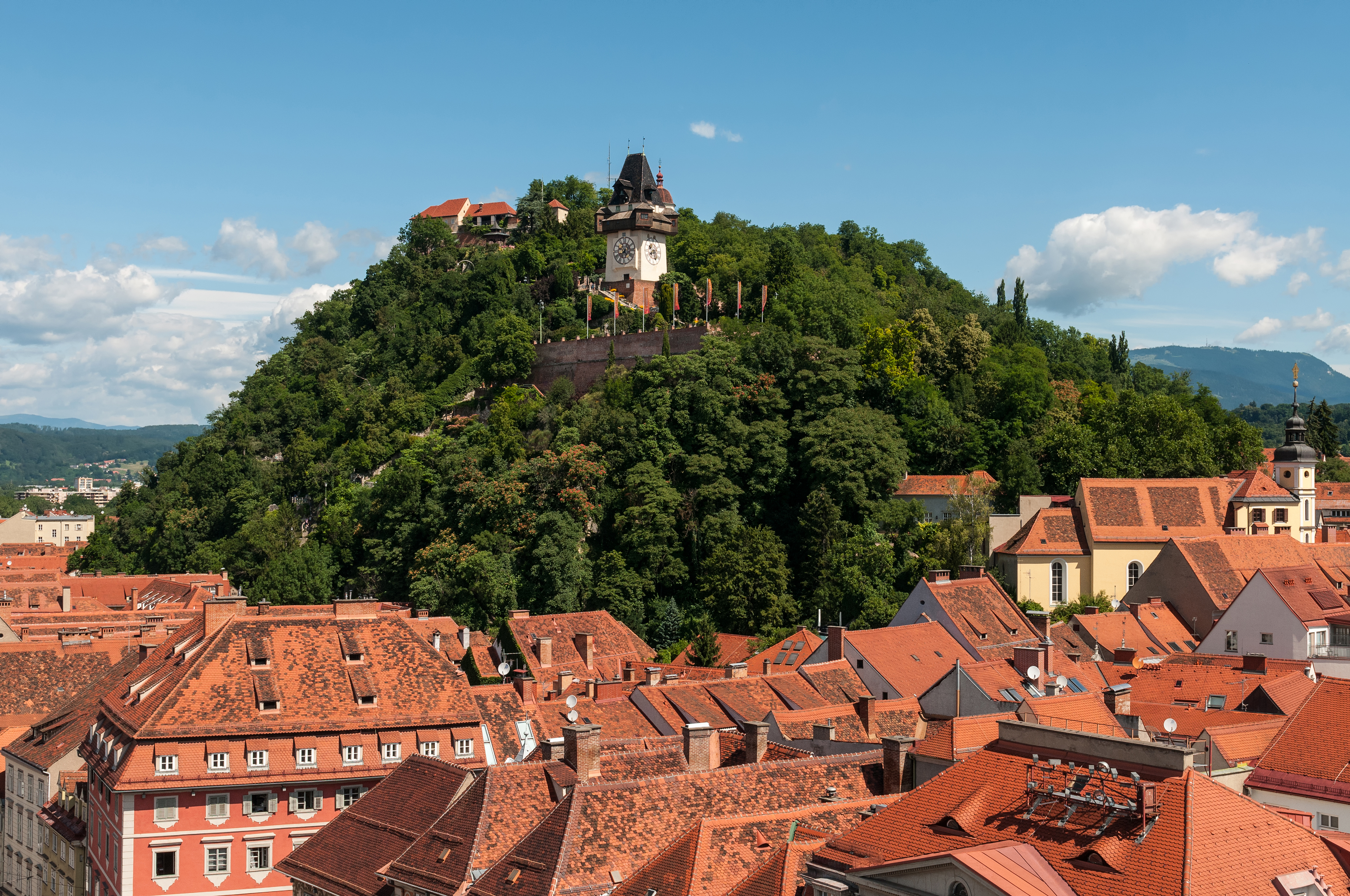
Deutsch: Schloßberg Graz, Blick von der Turmspitze des Rathauses
Čeština: Štýrský Hradec, pohled z věže radnice
Català: Castell del Pujol Graz, vista des de la torre de l'ajuntament
Español: Castillo de la Colina Graz, vista desde la torre del ayuntamiento
Русский: Шлоссберг Грац, Вид с башни ратуши
English: Castle mountain Graz, view from the spire of the town hall
|
|||||||||||||||||||||||
| Dat | ||||||||||||||||||||||||
| Sous | Travay pèsonèl | |||||||||||||||||||||||
| Kreyatè |
|
|||||||||||||||||||||||
| Pèmisyon : (Resèvi ak fichye sa a) |
|
|||||||||||||||||||||||


| Lieu de la prise de vue | | Voir cet endroit et d’autres images sur : OpenStreetMap |
|---|
| Position de l'objet | | Voir cet endroit et d’autres images sur : OpenStreetMap |
|---|
Distinctions
|
This image was selected as picture of the day on Wikimedia Commons for 6 July 2023. It was captioned as follows: English: Castle mountain Graz, view from the spire of the town hall. Other languages:
Čeština: Mohutná skála Schloßberg nad rakouským Štýrským Hradcem (Gratzem), z jehož radniční věže byl nafotografován tento snímek. Deutsch: Der Grazer Schloßberg. English: Castle mountain Graz, view from the spire of the town hall. Español: Schloßberg, vista desde la torre del ayuntamiento. Français : Le Schloßberg, colline de Graz (Autriche) abritant un jardin public et une forteresse. Vue ici depuis la tour de l'hôtel de ville. Italiano: Vista del monte castello di Graz dalla guglia del municipio, nella città di Graz in Austria. Nederlands: Blik op de Uhrturm op de Schlossberg in Graz, de hoofdstad van de Oostenrijkse deelstaat Stiermarken Português: Montanha do castelo em Graz, Áustria, vista da torre da prefeitura. |
Cette image a été promue au rang d'image de qualité d'après les critères du Guide des images.
|
Wikipedia-Landtagsprojekt/Steiermark 20165. of July 2016 in Graz More than 10 persons participated in this project voluntarily and without expense allowance.
|
|
 |
Usage informationIf you need more information how to use this file, please send an |
|
The making of this work was supported by Wikimedia Austria. For other files made with the support of Wikimedia Austria, please see the category Supported by Wikimedia Österreich. |
La réalisation de ce document a été parrainée par Skillshare.
Pour voir tous les fichiers concernés, consultez la catégorie Supported by Skillshare. |
- Ou gen dwa:
- pou pataje – pou kopye, distribiye epi difize ouvraj la
- pou remiks – pou adapte ouvraj la
- Selon kondisyon sa a yo:
- Rekonèt avèk non otè – Ou dwe bay enfòmasyon apwopriye sou otè a, bay yon lyen pou lisans lan, epi endike si te gen chanjman ki fèt. Ou ka fè sa nan nenpòt fason rezonab, men okenn fason ki sijere ke otè a soutni oswa apwouve itilizasyon ou an.
- Enfòmasyon sa yo ka pataje – Si ou fè rekopye, transfòme, oswa baze sou materyèl sa, ou dwe distribye kontribisyon ou anba menm oswa yon lisans konpatib avèk orijinal la.

Kondisyon itlizasyon

|
Vous avez la permission de copier, distribuer et modifier ce document selon les termes de la GNU Free Documentation License version 1.2 publiée par la Free Software Foundation, sans sections inaltérables, sans texte de première page de couverture et sans texte de dernière page de couverture. Un exemplaire de la licence est inclus dans la section intitulée GNU Free Documentation License. | 1.2 seulement |
Istorik fichye a
Klike sou yon dat/yon lè pou wè fichye a jan li te ye nan moman sa a.
| Dat ak lè | Minyati | Grandè yo | Itilizatè | Komantè | |
|---|---|---|---|---|---|
| Kounye a | 8 jiyè 2016 à 22:45 | | 4 288 × 2 848 (9,76 Mio) | Ralf Roletschek | sky denoised |
| 8 jiyè 2016 à 20:26 |  | 4 288 × 2 848 (10,28 Mio) | Ralf Roletschek |
Itilizasyon fichye sa a
Pa gen okenn paj ki itilize dosye sa a.
Itilizasyon global fichye a
Wiki sa a yo sèvi ak fichye sa a:
- Itilizasyon sou am.wikipedia.org
- Itilizasyon sou an.wikipedia.org
- Itilizasyon sou ar.wikipedia.org
- Itilizasyon sou arz.wikipedia.org
- Itilizasyon sou ast.wikipedia.org
- Itilizasyon sou av.wikipedia.org
- Itilizasyon sou az.wikipedia.org
- Itilizasyon sou ban.wikipedia.org
- Itilizasyon sou ba.wikipedia.org
- Itilizasyon sou be-tarask.wikipedia.org
- Itilizasyon sou bg.wikipedia.org
- Itilizasyon sou bn.wikipedia.org
- Itilizasyon sou ca.wikipedia.org
- Itilizasyon sou ceb.wikipedia.org
- Itilizasyon sou ce.wikipedia.org
- Itilizasyon sou cs.wikipedia.org
- Itilizasyon sou cv.wikipedia.org
- Itilizasyon sou cy.wikipedia.org
- Itilizasyon sou de.wikipedia.org
- Österreich
- Belagerung von Graz
- Wikipedia:Landtagsprojekt/Steiermark/Locations
- Wikipedia Diskussion:Hauptseite/Artikel des Tages/Archiv/Vorschläge/2018/Q1
- Wikipedia:Hauptseite/Archiv/13. März 2018
- Portal:Österreich/RegiowikiAT Redundanzen
- Benutzerin:Alfonsina2019
- Liste der denkmalgeschützten Objekte in Graz/Innere Stadt/O–Z
- Wikipedia:WikiProjekt Österreich/checks/Denkmalschutz/WP - WD diffs 02
- Itilizasyon sou de.wikiversity.org
- Itilizasyon sou de.wikivoyage.org
- Itilizasyon sou de.wiktionary.org
- Itilizasyon sou el.wikipedia.org
- Itilizasyon sou en.wikipedia.org
- Itilizasyon sou en.wikivoyage.org
- Itilizasyon sou eo.wikipedia.org
- Itilizasyon sou eo.wikivoyage.org
- Itilizasyon sou eu.wikipedia.org
- Itilizasyon sou fa.wikipedia.org
- Itilizasyon sou fi.wikipedia.org
Gade plis itilizasyon global fichye sa a.