
Fichye:St. John, U.S. Virgin Islands.jpg

Dimansyon previzyalizasyon sa a : 600 × 600 piksèl. Lòt rezolisyon yo: 240 × 240 piksèl | 480 × 480 piksèl | 768 × 768 piksèl | 1 024 × 1 024 piksèl | 2 400 × 2 400 piksèl.
Fichye orijinal (2 400 × 2 400 piksèl, gwosè fichye a : 2,74 Mio, tip MIME li ye : image/jpeg)
Rezime
| Deskripsyon |
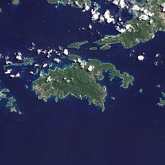
English: Natural-colour image of the Island of St. John island in the United States Virgin Islands.
|
| Dat | |
| Sous | NASA Earth Observatory |
| Kreyatè | Jesse Allen and Robert Simmon |
| Autres versions |


.jpg)

Image captured by the Advanced Land Imager (ALI) on NASA’s Earth Observing-1 (EO-1) satellite. EO-1 ALI data provided courtesy of the NASA EO-1 team.
Kondisyon itlizasyon
| Ce fichier provient de la NASA. Sauf exception, les documents créés par la NASA ne sont pas soumis à copyright. Pour plus d'informations, voir la politique de copyright de la NASA. | ||
 |
Attention :
|
| Annotations | This image is annotated: View the annotations at Commons |
Istorik fichye a
Klike sou yon dat/yon lè pou wè fichye a jan li te ye nan moman sa a.
| Dat ak lè | Minyati | Grandè yo | Itilizatè | Komantè | |
|---|---|---|---|---|---|
| Kounye a | 20 janvye 2011 à 10:13 | | 2 400 × 2 400 (2,74 Mio) | Originalwana | {{Information |Description={{en|1=Natural-colour image of the eastern half of St. John. Settlements—marked by curving roads and light roofs—line the irregular coastline. The pinpoints of white in Coral Bay are probably boats. The island’s interior |
Itilizasyon fichye sa a
Pa gen okenn paj ki itilize dosye sa a.
Itilizasyon global fichye a
Wiki sa a yo sèvi ak fichye sa a:
- Itilizasyon sou arz.wikipedia.org
- Itilizasyon sou ast.wikipedia.org
- Itilizasyon sou ca.wikipedia.org
- Itilizasyon sou ceb.wikipedia.org
- Itilizasyon sou cy.wikipedia.org
- Itilizasyon sou de.wikivoyage.org
- Itilizasyon sou en.wikipedia.org
- Itilizasyon sou en.wikisource.org
- Itilizasyon sou eo.wikipedia.org
- Itilizasyon sou es.wikipedia.org
- Itilizasyon sou eu.wikipedia.org
- Itilizasyon sou fi.wikipedia.org
- Itilizasyon sou frr.wikipedia.org
- Itilizasyon sou fr.wikivoyage.org
- Itilizasyon sou gl.wikipedia.org
- Itilizasyon sou id.wikipedia.org
- Itilizasyon sou lb.wikipedia.org
- Itilizasyon sou pl.wikipedia.org
- Itilizasyon sou tg.wikipedia.org
- Itilizasyon sou tl.wikipedia.org
- Itilizasyon sou uk.wikipedia.org
- Itilizasyon sou vec.wikipedia.org
- Itilizasyon sou www.wikidata.org