
Fichye:Satellite image of Philippines in March 2002.jpg

Dimansyon previzyalizasyon sa a : 460 × 600 piksèl. Lòt rezolisyon yo: 184 × 240 piksèl | 368 × 480 piksèl | 589 × 768 piksèl | 785 × 1 024 piksèl | 1 570 × 2 048 piksèl | 4 600 × 6 000 piksèl.
Fichye orijinal (4 600 × 6 000 piksèl, gwosè fichye a : 3,58 Mio, tip MIME li ye : image/jpeg)
Rezime
| Deskripsyon |
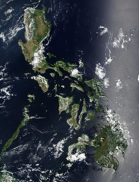
Satellite image of Philippines in March 2002. |
| Dat | |
| Sous | http://visibleearth.nasa.gov/view_rec.php?id=2689 |
| Kreyatè | NASA |
Kondisyon itlizasyon
| Ce fichier provient de la NASA. Sauf exception, les documents créés par la NASA ne sont pas soumis à copyright. Pour plus d'informations, voir la politique de copyright de la NASA. | ||
 |
Attention :
|
Istorik fichye a
Klike sou yon dat/yon lè pou wè fichye a jan li te ye nan moman sa a.
| Dat ak lè | Minyati | Grandè yo | Itilizatè | Komantè | |
|---|---|---|---|---|---|
| Kounye a | 21 desanm 2004 à 11:32 | | 4 600 × 6 000 (3,58 Mio) | Hautala | {{PD-USGov-NASA}} Satellite image of Philippines in March 2002. Taken from NASA's Visible Earth http://visibleearth.nasa.gov/cgi-bin/viewrecord?12847 . Description: Red dots (or outlines in the high-resolution imagery) indicate MODIS9 detection of thermal |
Itilizasyon fichye sa a
paj sa a itilize fichye sa a:
Itilizasyon global fichye a
Wiki sa a yo sèvi ak fichye sa a:
- Itilizasyon sou af.wikipedia.org
- Itilizasyon sou bg.wikipedia.org
- Itilizasyon sou bn.wikipedia.org
- Itilizasyon sou ca.wikipedia.org
- Itilizasyon sou da.wikipedia.org
- Itilizasyon sou de.wikipedia.org
- Itilizasyon sou de.wikinews.org
- Itilizasyon sou en.wikipedia.org
- Outline of the Philippines
- Deforestation by continent
- Deforestation in the Philippines
- Wikipedia:Featured picture candidates/Satellite image of the Philippines
- Wikipedia:Featured picture candidates/September-2012
- Wikipedia:Featured picture candidates/February-2014
- Wikipedia:Featured picture candidates/Philippines (Satellite)
- Itilizasyon sou en.wikiversity.org
- Itilizasyon sou en.wiktionary.org
- Itilizasyon sou fi.wikipedia.org
- Itilizasyon sou gl.wikipedia.org
- Itilizasyon sou he.wikipedia.org
- תבנית:הידעת? 5 בנובמבר - סדרה 2
- פורטל:ארצות הברית/הידעת?/קטעי הידעת
- פורטל:ארצות הברית/הידעת?/50
- פורטל:יפן/הידעת?/קטעי הידעת
- תבנית:הידעת? 5 בנובמבר 2014
- ויקיפדיה:הידעת?/2014/נובמבר
- ויקיפדיה:הידעת?/2016/נובמבר
- תבנית:הידעת? 5 בנובמבר 2016
- ויקיפדיה:הידעת?/2018/נובמבר
- תבנית:הידעת? 18 בנובמבר 2018
- תבנית:הידעת? 1 בנובמבר 2019
- ויקיפדיה:הידעת?/2019/נובמבר
- ויקיפדיה:הידעת?/2021/נובמבר
- תבנית:הידעת? 7 בנובמבר 2021
- פורטל:יפן/הידעת?/23
- תבנית:הידעת? 5 בנובמבר 2023
- ויקיפדיה:הידעת?/2023/נובמבר
- Itilizasyon sou incubator.wikimedia.org
- Itilizasyon sou mdf.wikipedia.org
- Itilizasyon sou nl.wikipedia.org
- Itilizasyon sou nl.wiktionary.org
- Itilizasyon sou no.wikipedia.org
- Itilizasyon sou pap.wikipedia.org
- Itilizasyon sou pl.wikinews.org
- Itilizasyon sou qu.wikipedia.org
- Itilizasyon sou sk.wikipedia.org
- Itilizasyon sou sm.wikipedia.org
- Itilizasyon sou sr.wikinews.org
- Itilizasyon sou trv.wikipedia.org
Gade plis itilizasyon global fichye sa a.