
Fichye:Ohio Portage Kent.png

Dimansyon previzyalizasyon sa a : 800 × 468 piksèl. Lòt rezolisyon yo: 320 × 187 piksèl | 640 × 374 piksèl | 1 025 × 599 piksèl.
Fichye orijinal (1 025 × 599 piksèl, gwosè fichye a : 141 kio, tip MIME li ye : image/png)
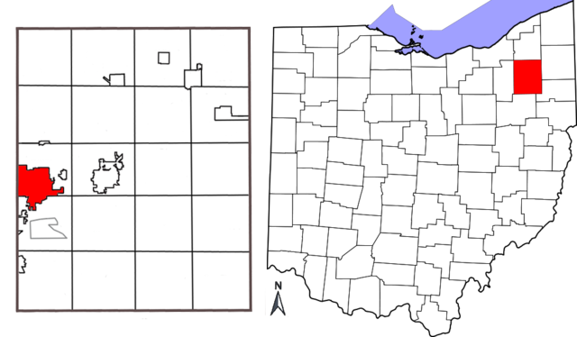
| Deskripsyon | Combination map showing location of Kent, Ohio within Portage County and Portage County's location within the state of Ohio. Original map of Ohio by David Benbennick; map of Portage County with Kent highlighted made by Jon Ridinger. |
| Dat | (UTC) |
| Sous | |
| Kreyatè |
| Cette image a été retouchée, ce qui signifie qu'elle a été modifiée par ordinateur et est différente de l'image d'origine. Liste des modifications : added two maps together; removed distance chart from Portage County map; moved compass. L'image d'origine se trouve ici : Portage County Kent.png:
|
Fichye sa a distribiye selon lisans Creative Commons.
- Ou gen dwa:
- pou pataje – pou kopye, distribiye epi difize ouvraj la
- pou remiks – pou adapte ouvraj la
- Selon kondisyon sa a yo:
- Rekonèt avèk non otè – Ou dwe bay enfòmasyon apwopriye sou otè a, bay yon lyen pou lisans lan, epi endike si te gen chanjman ki fèt. Ou ka fè sa nan nenpòt fason rezonab, men okenn fason ki sijere ke otè a soutni oswa apwouve itilizasyon ou an.
- Enfòmasyon sa yo ka pataje – Si ou fè rekopye, transfòme, oswa baze sou materyèl sa, ou dwe distribye kontribisyon ou anba menm oswa yon lisans konpatib avèk orijinal la.
Journal des téléversements d’origine
This image is a derivative work of the following images:
- File:Map_of_Ohio_highlighting_Portage_County.svg licensed with PD-self
- 2006-02-12T16:10:28Z David Benbennick 3675x3995 (59503 Bytes) {{subst:User:Dbenbenn/clm|county=Portage County|state=Ohio|type=county}}
- File:Portage_County_Kent.png licensed with Cc-by-3.0
- 2010-05-01T03:26:12Z JonRidinger 425x577 (81460 Bytes) Minor correction
- 2010-05-01T03:22:22Z JonRidinger 425x577 (76288 Bytes) Straightened map, cropped, removed extra white areas
- 2008-05-16T02:27:08Z JonRidinger 489x615 (44136 Bytes) {{Information |Description= Map of Portage County, Ohio with the city of Kent highlighted. |Source=self-made |Date= 15 May 2008 |Author= [[User:JonRidinger|JonRidinger]] |Permission= Public domain |other_versions= }} [[Categ
Téléversé avec derivativeFX
Istorik fichye a
Klike sou yon dat/yon lè pou wè fichye a jan li te ye nan moman sa a.
| Dat ak lè | Minyati | Grandè yo | Itilizatè | Komantè | |
|---|---|---|---|---|---|
| Kounye a | 7 me 2010 à 12:12 | | 1 025 × 599 (141 kio) | JonRidinger | {{Information |Description=Combination map showing location of Kent, Ohio within Portage County and Portage County's location within the state of Ohio. Original map of Ohio by [[User:Dbenbenn|David B |
Itilizasyon fichye sa a
paj sa a itilize fichye sa a:
Itilizasyon global fichye a
Wiki sa a yo sèvi ak fichye sa a:
- Itilizasyon sou ar.wikipedia.org
- Itilizasyon sou arz.wikipedia.org
- Itilizasyon sou azb.wikipedia.org
- Itilizasyon sou bn.wikipedia.org
- Itilizasyon sou ca.wikipedia.org
- Itilizasyon sou ceb.wikipedia.org
- Itilizasyon sou cy.wikipedia.org
- Itilizasyon sou en.wikipedia.org
- Itilizasyon sou eu.wikipedia.org
- Itilizasyon sou fa.wikipedia.org
- Itilizasyon sou fi.wikipedia.org
- Itilizasyon sou fr.wikipedia.org
- Itilizasyon sou id.wikipedia.org
- Itilizasyon sou it.wikipedia.org
- Itilizasyon sou no.wikipedia.org
- Itilizasyon sou sh.wikipedia.org
- Itilizasyon sou sr.wikipedia.org
- Itilizasyon sou sv.wikipedia.org
- Itilizasyon sou tr.wikipedia.org
- Itilizasyon sou tt.wikipedia.org
- Itilizasyon sou ur.wikipedia.org
- Itilizasyon sou vo.wikipedia.org
- Itilizasyon sou www.wikidata.org
- Itilizasyon sou zh-min-nan.wikipedia.org
- Itilizasyon sou zh.wikipedia.org