Fichye:Map of Sunda and Sahul.svg

Le contenu de la page n’est pas pris en charge dans d’autres langues.
Depi Wikipedya, ansiklopedi lib

Fichye orijinal(Fichye SVG, rezolisyon de 976 × 907 piksèl, gwosè fichye : 845 kio)

Afficher cette image en .

Fichye sa a sòti nan Wikimedia Commons e ka sèvi nan lòt pwojè. Desktripsyon ki sou paj li file description page ekri anba a.

Rezime

Description
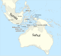
Català: Mapa de Sonda i Sahul (marcat per un contorn de 125 m de profunditat) i la Línia de Wallace, la Línia de Weber i la Línia de Lydekker.
English: Map of Sunda and Sahul (marked by 125m depth contour) and the Wallace Line, the Weber Line and the Lydekker Line.
Key
InfoField
 
sea
 
current land extent (0BP)
 
land extent at Last Glacial Maximum (23000+-3000 BP)
Dat
Sous

Travay pèsonèl, based on file:map of Sunda and Sahul.png and using

Créé par
 Données géotemporelles
Système de coordonnées equirectangular
Rectangle englobant
N: 20.2°N
W: 91°E E: 162.8°E
S: 45°S
Autres versions
Other related versions: Map of Sunda and Sahul.png


Translate this file This SVG file contains embedded text that can be translated into your language, using any capable SVG editor, text editor or the SVG Translate tool. For more information see: About translating SVG files.
This file is translated using SVG <switch> elements. All translations are stored in the same file! Learn more.

For most Wikipedia projects, you can embed the file normally (without a lang parameter). The Wikipedia will use its language if the SVG file supports that language. For example, the German Wikipedia will use German if the SVG file has German. To embed this file in a particular language use the lang parameter with the appropriate language code, e.g. [[File:Map of Sunda and Sahul.svg|lang=en]] for the English version. Do not specify a lang parameter if it is not needed. The parameter may prevent the use of a subsequent translation.

To translate the text into your language, you can use the SVG Translate tool. Alternatively, you can download the file to your computer, add your translations using whatever software you're familiar with, and re-upload it with the same name. You will find help in Graphics Lab if you're not sure how to do this.

Kondisyon itlizasyon

Moi, en tant que détenteur des droits d’auteur sur cette œuvre, je la publie sous les licences suivantes :
w:fr:Creative Commons
Rekonèt avèk non otè Enfòmasyon sa yo ka pataje
Ou gen dwa:
  • pou pataje – pou kopye, distribiye epi difize ouvraj la
  • pou remiks – pou adapte ouvraj la
Selon kondisyon sa a yo:
  • Rekonèt avèk non otè – Ou dwe bay enfòmasyon apwopriye sou otè a, bay yon lyen pou lisans lan, epi endike si te gen chanjman ki fèt. Ou ka fè sa nan nenpòt fason rezonab, men okenn fason ki sijere ke otè a soutni oswa apwouve itilizasyon ou an.
  • Enfòmasyon sa yo ka pataje – Si ou fè rekopye, transfòme, oswa baze sou materyèl sa, ou dwe distribye kontribisyon ou anba menm oswa yon lisans konpatib avèk orijinal la.
GNU head Ou bay pèmisyon pou kopye, distribye ak/oswa modifye dokiman sa a dapre kondisyon GNU Free Documentation License, Vèsyon. 1.2 oswa nenpòt vèsyon ki pibliye pita pa Free Software Foundation; san okenn Seksyon ki pa ka chanje, pa gen okenn Tèks ak premye paj kouvèti, epi pa gen okenn Tèks Denyè-Kouvèti. Gen yon kopi lisans lan nan seksyon ki rele GNU Free Documentation License.
Chwazi lisans ou vle a.

Légendes

Ajoutez en une ligne la description de ce que représente ce fichier

Éléments décrits dans ce fichier

dépeint français

Istorik fichye a

Klike sou yon dat/yon lè pou wè fichye a jan li te ye nan moman sa a.

Dat ak lèMinyatiGrandè yoItilizatèKomantè
Kounye a12 avril 2024 à 23:42Minyati pou vèsyon 12 avril 2024 à 23:42976 × 907 (845 kio)ManlleusFile uploaded using svgtranslate tool (https://svgtranslate.toolforge.org/). Added translation for ca.
12 avril 2024 à 23:34Minyati pou vèsyon 12 avril 2024 à 23:34976 × 907 (845 kio)ManlleusFile uploaded using svgtranslate tool (https://svgtranslate.toolforge.org/). Added translation for ca.
16 janvye 2023 à 15:07Minyati pou vèsyon 16 janvye 2023 à 15:07976 × 907 (841 kio)Kanguole{{Map |Description={{en|Map of Sunda and Sahul (marked by 125m depth contour) and the Wallace Line, the Weber Line and the Lydekker Line.}} |Projection=equirectangular |Latitude=-45/20.2 |Longitude=91/162.8 |Warp status=skip |Source={{own}}, using * Coastline from [http://www.naturalearthdata.com/downloads/50m-physical-vectors/ Natural Earth 1:50m Physical Vectors] * 125m depth contour derived...

paj sa a itilize fichye sa a:

Itilizasyon global fichye a

Metadone