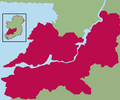
Fichye:Kingdom of Thomond.png
Apparence

Dimansyon previzyalizasyon sa a : 800 × 462 piksèl. Lòt rezolisyon yo: 320 × 185 piksèl | 640 × 369 piksèl | 1 024 × 591 piksèl | 1 655 × 955 piksèl.
Fichye orijinal (1 655 × 955 piksèl, gwosè fichye a : 137 kio, tip MIME li ye : image/png)
Istorik fichye a
Klike sou yon dat/yon lè pou wè fichye a jan li te ye nan moman sa a.
| Dat ak lè | Minyati | Grandè yo | Itilizatè | Komantè | |
|---|---|---|---|---|---|
| Kounye a | 7 desanm 2021 à 18:24 |  | 1 655 × 955 (137 kio) | SKIBLY101 | much more realistic map... to the west are uí fidgenti, to the south the deisis and the east are o'carroll ely, why dont you give an actual source before challenging this instead of drawing arbitrary lines based on nothing |
| 20 jen 2009 à 20:48 |  | 539 × 449 (30 kio) | Thomas Gun | colour | |
| 19 avril 2009 à 06:24 |  | 539 × 449 (32 kio) | Thomas Gun | colour | |
| 29 desanm 2008 à 08:07 |  | 539 × 449 (36 kio) | Thomod | {{Information |Description= |Source= |Date= |Author= |Permission= |other_versions= }} | |
| 29 desanm 2008 à 08:04 |  | 539 × 449 (36 kio) | Thomod | {{Information |Description= |Source= |Date= |Author= |Permission= |other_versions= }} | |
| 29 desanm 2008 à 08:01 |  | 539 × 449 (36 kio) | Thomod | {{Information |Description= |Source= |Date= |Author= |Permission= |other_versions= }} | |
| 29 desanm 2008 à 07:54 |  | 539 × 449 (36 kio) | Thomod | {{Information |Description= |Source= |Date= |Author= |Permission= |other_versions= }} | |
| 26 desanm 2008 à 10:34 |  | 357 × 430 (37 kio) | Thomod | {{Information |Description= Rough map of the Kingdom of Thomond. Most sources describe it as in the area of the modern day Diocese of Killaloe, this is the boundaries which have been used |Source=myself |Date=26 December 2008 |Author=self-created |Permiss | |
| 26 desanm 2008 à 10:13 |  | 357 × 430 (38 kio) | Thomod | {{Information |Description= Rough map of the Kingdom of Thomond. Most sources describe it as in the area of the modern day Diocese of Killaloe, this is the boundaries which have been used |Source=myself |Date=26 December 2008 |Author=self-created |Permiss |
Itilizasyon fichye sa a
Pa gen okenn paj ki itilize dosye sa a.
Itilizasyon global fichye a
Wiki sa a yo sèvi ak fichye sa a:
- Itilizasyon sou ca.wikipedia.org
- Itilizasyon sou de.wikipedia.org
- Itilizasyon sou en.wikipedia.org
- Itilizasyon sou es.wikipedia.org
- Itilizasyon sou eu.wikipedia.org
- Itilizasyon sou fr.wikipedia.org
- Itilizasyon sou ga.wikipedia.org
- Itilizasyon sou id.wikipedia.org
- Itilizasyon sou it.wikipedia.org
- Itilizasyon sou ko.wikipedia.org
- Itilizasyon sou no.wikipedia.org
- Itilizasyon sou ru.wikipedia.org
- Itilizasyon sou uk.wikipedia.org
- Itilizasyon sou www.wikidata.org
