Fichye:Grossgliederung Europas-fr.svg

Le contenu de la page n’est pas pris en charge dans d’autres langues.
Depi Wikipedya, ansiklopedi lib

Fichye orijinal(Fichye SVG, rezolisyon de 683 × 709 piksèl, gwosè fichye : 938 kio)

Fichye sa a sòti nan Wikimedia Commons e ka sèvi nan lòt pwojè. Desktripsyon ki sou paj li file description page ekri anba a.

Rezime

Deskripsyon

[modifye]

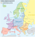
Aragonés: Rechions europeyas proposatas por Ständiger Ausschuss für geographische Namen (StAGN)
Català: Regions europees proposades per Ständiger Ausschuss für geographische Namen (StAGN)
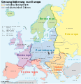
Deutsch: Großgliederung Europas, Vorschlag des Ständigen Ausschuss für geographische Namen (StAGN)
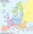
English: European regions as proposed by Ständiger Ausschuss für geographische Namen (StAGN)
Español: Regiones europeas propuestas por Ständiger Ausschuss für geographische Namen (StAGN)
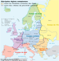
Français : Carte des régions d'Europe, en allemand, selon le Ständigen Ausschuss für geographische Namen (StAGN)
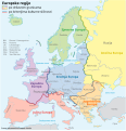
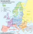
Hrvatski: Pregled europskih regija po kriterijima kulture i po državnim granicama
Polski: Mapa regionów europejskich, w języku niemieckim, wg propozycjiStałego Komitetu ds. Nazw Geograficznych (StAGN)
Македонски: Карта на регионите во Европа според ЕУ на македонски.
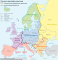
Русский: Европейские регионы
Українська: Європейські регіони на основі пропозиції Ständiger Ausschuss für geographische Namen (StAGN)
中文 欧洲
العربية : خارطة مناطق ودُول أوروپَّا وفقًا لِمُؤسسة Ständiger Ausschuss für geographische Namen (StAGN)
Dat
Sous

self-made, translation of a map from NordNordWest and an idea from Lencer using

  • P. Jordan: „Großgliederung Europas nach kulturräumlichen Kriterien“, Europa Regional 13 (2005), Heft 4, Leibniz-Institut für Länderkunde, Leipzig
  • Karte Europa Grünes Band.png
Kreyatè NordNordWest, translated by MaCRoEco
Autres versions

[modifye]

Kartenwerkstatt
Cette carte a été créée ou améliorée dans le Kartenwerkstatt (Atelier cartographique allemand). Vous pouvez également y proposer des cartes à améliorer.

Translate this file This SVG file contains embedded text that can be translated into your language, using any capable SVG editor, text editor or the SVG Translate tool. For more information see: About translating SVG files.

Kondisyon itlizasyon

Moi, en tant que détenteur des droits d’auteur sur cette œuvre, je la publie sous les licences suivantes :
GNU head Ou bay pèmisyon pou kopye, distribye ak/oswa modifye dokiman sa a dapre kondisyon GNU Free Documentation License, Vèsyon. 1.2 oswa nenpòt vèsyon ki pibliye pita pa Free Software Foundation; san okenn Seksyon ki pa ka chanje, pa gen okenn Tèks ak premye paj kouvèti, epi pa gen okenn Tèks Denyè-Kouvèti. Gen yon kopi lisans lan nan seksyon ki rele GNU Free Documentation License.
w:fr:Creative Commons
Rekonèt avèk non otè Enfòmasyon sa yo ka pataje
Fichye sa a distribiye selon lisans Creative Commons.
Ou gen dwa:
  • pou pataje – pou kopye, distribiye epi difize ouvraj la
  • pou remiks – pou adapte ouvraj la
Selon kondisyon sa a yo:
  • Rekonèt avèk non otè – Ou dwe bay enfòmasyon apwopriye sou otè a, bay yon lyen pou lisans lan, epi endike si te gen chanjman ki fèt. Ou ka fè sa nan nenpòt fason rezonab, men okenn fason ki sijere ke otè a soutni oswa apwouve itilizasyon ou an.
  • Enfòmasyon sa yo ka pataje – Si ou fè rekopye, transfòme, oswa baze sou materyèl sa, ou dwe distribye kontribisyon ou anba menm oswa yon lisans konpatib avèk orijinal la.
Chwazi lisans ou vle a.

Légendes

Ajoutez en une ligne la description de ce que représente ce fichier

Éléments décrits dans ce fichier

dépeint français

16 jen 2008

type MIME français

image/svg+xml

Istorik fichye a

Klike sou yon dat/yon lè pou wè fichye a jan li te ye nan moman sa a.

Dat ak lèMinyatiGrandè yoItilizatèKomantè
Kounye a11 jen 2021 à 15:08Minyati pou vèsyon 11 jen 2021 à 15:08683 × 709 (938 kio)Martin TauchmanGeographical name of Czechia
29 me 2020 à 23:37Minyati pou vèsyon 29 me 2020 à 23:37683 × 709 (926 kio)AndreasFile uploaded using svgtranslate tool (https://svgtranslate.toolforge.org/). Added translation for rm.
30 jiyè 2008 à 18:57Minyati pou vèsyon 30 jiyè 2008 à 18:57683 × 709 (855 kio)LycaonReverted to version as of 00:13, 17 June 2008
30 jiyè 2008 à 14:08Minyati pou vèsyon 30 jiyè 2008 à 14:08683 × 709 (855 kio)NordNordWestReverted to version as of 00:13, 17 June 2008, Turkey completely europeen just political intention of User:European Boy
17 jen 2008 à 00:13Minyati pou vèsyon 17 jen 2008 à 00:13683 × 709 (855 kio)MaCRoEco== Beschreibung == {{Information |Description= {{de|Großgliederung Europas, Vorschlag des Ständigen Ausschuss für geographische Namen (StAGN), deutsche SVG-Version}} {{en|European regions as propose

paj sa a itilize fichye sa a:

Itilizasyon global fichye a

Wiki sa a yo sèvi ak fichye sa a:

Metadone