
Fichye:Crookston Commercial Historic District.jpg

Dimansyon previzyalizasyon sa a : 757 × 599 piksèl. Lòt rezolisyon yo: 303 × 240 piksèl | 606 × 480 piksèl | 956 × 757 piksèl.
Fichye orijinal (956 × 757 piksèl, gwosè fichye a : 84 kio, tip MIME li ye : image/jpeg)
|
Ceci est une photographie d’un monument référencé dans le National Register of Historic Places des États-Unis sous le numéro 84002709. |
| Deskripsyon |
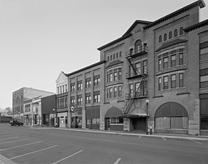
English: Buildings in the Crookston Commercial Historic District in central Crookston, Polk County, Minnesota, United States. The district reflects the city's early period of growth, which was prompted by agriculture and the railroad industry. It remains a large, and mostly intact, concentration of late nineteenth- and early twentieth-century commercial structures and is listed on the National Register of Historic Places. |
|||||
| Dat | Date inconnue | |||||
| Sous | Library of Congress Prints and Photographs Division, Historic American Buildings Survey: MINN,60-CROK,1-6 | |||||
| Kreyatè | Anonyme | |||||
| Pèmisyon : (Resèvi ak fichye sa a) |
|

| Position de l'objet | | Voir cet endroit et d’autres images sur : OpenStreetMap |
|---|

|
Cette image est disponible sur la Prints and Photographs division de la Bibliothèque du Congrès des États-Unis sous le numéro d’identification hhh.mn0444.
Ce bandeau n’indique rien sur le statut de l’œuvre au regard du droit d'auteur. Un bandeau de droit d’auteur est requis. Voir Commons:À propos des licences pour plus d’informations.
|
Istorik fichye a
Klike sou yon dat/yon lè pou wè fichye a jan li te ye nan moman sa a.
| Dat ak lè | Minyati | Grandè yo | Itilizatè | Komantè | |
|---|---|---|---|---|---|
| Kounye a | 31 janvye 2009 à 14:07 | | 956 × 757 (84 kio) | Cropbot | upload cropped version, operated by User:Finavon. Summary: border cropped |
| 29 janvye 2009 à 14:35 |  | 1 024 × 818 (96 kio) | Nyttend | {{Information |Description=Photograph from the {{w|Historic American Buildings Survey}} of buildings in the {{w|Crookston Commercial Historic District}}, an area listed on the {{w|National Register of Historic Places}}. The district is located in central |
Itilizasyon fichye sa a
paj sa a itilize fichye sa a:
Itilizasyon global fichye a
Wiki sa a yo sèvi ak fichye sa a:
- Itilizasyon sou ar.wikipedia.org
- Itilizasyon sou arz.wikipedia.org
- Itilizasyon sou azb.wikipedia.org
- Itilizasyon sou be.wikipedia.org
- Itilizasyon sou ca.wikipedia.org
- Itilizasyon sou ceb.wikipedia.org
- Itilizasyon sou ce.wikipedia.org
- Itilizasyon sou dag.wikipedia.org
- Itilizasyon sou de.wikipedia.org
- Itilizasyon sou en.wikipedia.org
- Itilizasyon sou en.wikivoyage.org
- Itilizasyon sou es.wikipedia.org
- Itilizasyon sou eu.wikipedia.org
- Itilizasyon sou fa.wikipedia.org
- Itilizasyon sou fr.wikipedia.org
- Itilizasyon sou hu.wikipedia.org
- Itilizasyon sou ia.wikipedia.org
- Itilizasyon sou ko.wikipedia.org
- Itilizasyon sou ky.wikipedia.org
- Itilizasyon sou lld.wikipedia.org
- Itilizasyon sou pt.wikipedia.org
- Itilizasyon sou ru.wikipedia.org
- Itilizasyon sou sh.wikipedia.org
- Itilizasyon sou sr.wikipedia.org
- Itilizasyon sou tr.wikipedia.org
- Itilizasyon sou tt.wikipedia.org
- Itilizasyon sou uk.wikipedia.org
- Itilizasyon sou ur.wikipedia.org
- Itilizasyon sou uz.wikipedia.org
- Itilizasyon sou vi.wikipedia.org
- Itilizasyon sou www.wikidata.org
- Itilizasyon sou zh-min-nan.wikipedia.org