
Fichye:Columbia River Mouth and Bar.jpg
Dimansyon previzyalizasyon sa a : 800 × 517 piksèl. Lòt rezolisyon yo: 320 × 207 piksèl | 640 × 414 piksèl | 1 024 × 662 piksèl | 1 280 × 827 piksèl | 2 560 × 1 654 piksèl | 3 957 × 2 557 piksèl.
Fichye orijinal (3 957 × 2 557 piksèl, gwosè fichye a : 4,04 Mio, tip MIME li ye : image/jpeg)
Rezime
| Deskripsyon |
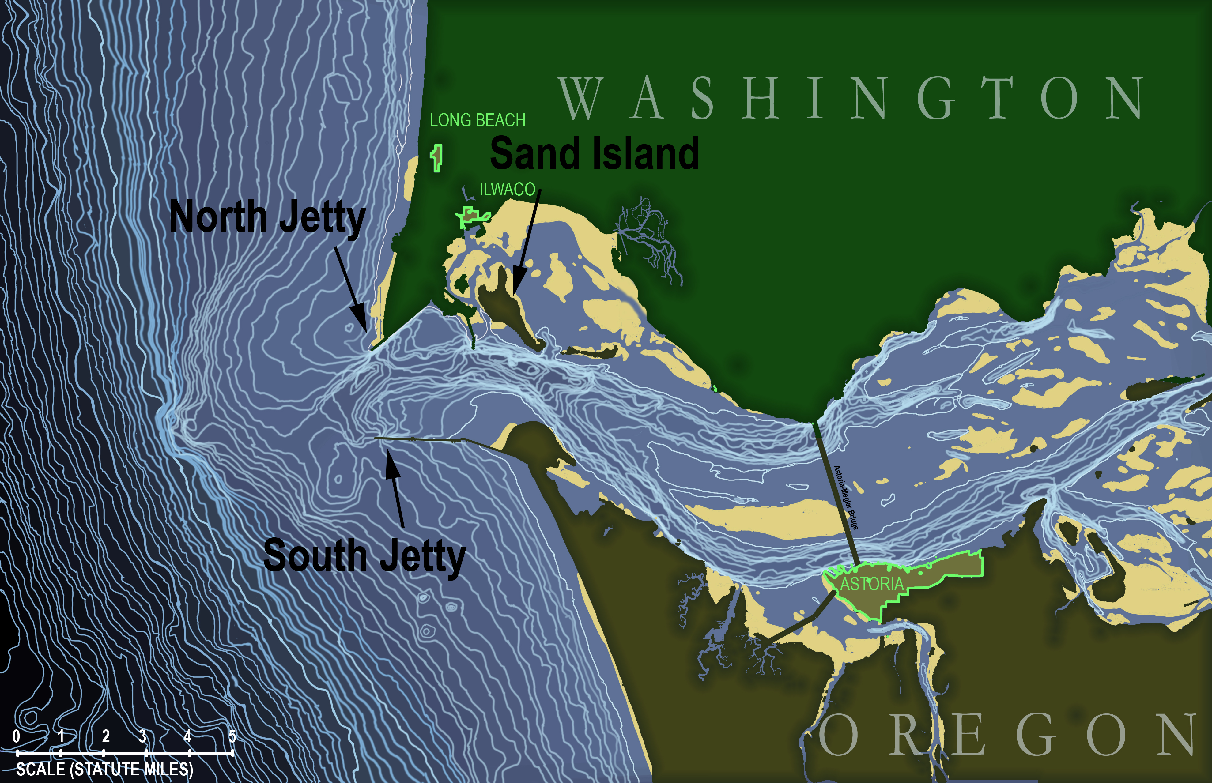
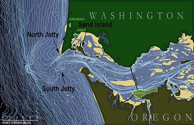
English: Topographic map of the underwater area in and around the mouth of the Columbia River in the state of Oregon, USA. Map is based on soundings in feet taken by the National Oceanic and Atmospheric Administration and published in NOAA navigational chart #18521, "Columbia River - Pacific Ocean to Harrington Point", August 2009 (original chart available here: http://www.charts.noaa.gov/OnLineViewer/18521.shtml) which itself is a public domain image.
Topographic lines on this map begin at a depth of 15 feet and occur at 5-foot intervals continuously down to 310 feet (i.e., the edge of the map). Land masses (states of Washington and Oregon) are shown in dark green with urbanized areas highlighted around the edge in bright green. Tidal sand bars are shown in yellow. Français : Carte topographique de l'estuaire et de la zone sous-marine périphérique à l'embouchure du fleuve Columbia dans l'état de l'Oregon, aux États-Unis. D'après les données de laNOAA (Administration nationale des océans et de l'atmosphère ; carte de navigation n ° 18521, "Fleuve Columbia - océan Pacifique à Harrington Point", août 2009 ; la carte originale est disponible ici: http://www.charts.noaa.gov/OnLineViewer/18521.shtml, elle-même publiée sous licence domaine public). Les lignes topographiques commencent à une profondeur de 15 pieds et apparaissent à intervalles de 5 pieds de manière continue jusqu'à 310 pieds (bord gauche de la carte). Les masses continentales (États de Washington et de l'Oregon) apparaissent en vert foncé avec les zones urbanisées surlignées en vert clair. Les bancs de sable de marée sont indiquées en jaune. |
| Dat | |
| Sous | Travay pèsonèl |
| Kreyatè | KDS444 |
Kondisyon itlizasyon
Moi, en tant que détenteur des droits d’auteur sur cette œuvre, je la publie sous la licence suivante :
Fichye sa a distribiye selon lisans Creative Commons.
- Ou gen dwa:
- pou pataje – pou kopye, distribiye epi difize ouvraj la
- pou remiks – pou adapte ouvraj la
- Selon kondisyon sa a yo:
- Rekonèt avèk non otè – Ou dwe bay enfòmasyon apwopriye sou otè a, bay yon lyen pou lisans lan, epi endike si te gen chanjman ki fèt. Ou ka fè sa nan nenpòt fason rezonab, men okenn fason ki sijere ke otè a soutni oswa apwouve itilizasyon ou an.
- Enfòmasyon sa yo ka pataje – Si ou fè rekopye, transfòme, oswa baze sou materyèl sa, ou dwe distribye kontribisyon ou anba menm oswa yon lisans konpatib avèk orijinal la.
Istorik fichye a
Klike sou yon dat/yon lè pou wè fichye a jan li te ye nan moman sa a.
| Dat ak lè | Minyati | Grandè yo | Itilizatè | Komantè | |
|---|---|---|---|---|---|
| Kounye a | 18 desanm 2012 à 23:38 | | 3 957 × 2 557 (4,04 Mio) | KDS444 | Added labels for the towns of Ilwaco and Long Beach, Washington, and made labels for North Jetty, South Jetty, and Sand Island more visible in thumbnail view. |
| 16 desanm 2012 à 12:57 |  | 3 957 × 2 557 (4,05 Mio) | KDS444 | Added labels for jetties and Sand Island | |
| 16 desanm 2012 à 12:27 |  | 3 957 × 2 557 (4,03 Mio) | KDS444 | Added all contour lines down to 310 ft. | |
| 15 out 2012 à 19:20 |  | 900 × 582 (472 kio) | KDS444 | corrections | |
| 12 out 2012 à 20:37 |  | 1 200 × 775 (697 kio) | KDS444 |
Itilizasyon fichye sa a
paj sa a itilize fichye sa a:
Itilizasyon global fichye a
Wiki sa a yo sèvi ak fichye sa a:
- Itilizasyon sou ca.wikipedia.org
- Itilizasyon sou en.wikipedia.org
- Itilizasyon sou fr.wikipedia.org
- Itilizasyon sou he.wikipedia.org
- Itilizasyon sou www.wikidata.org