
Fichye:Apprx. PRC-DPRK border around Baekdu-Changbai Mountain.PNG

Dimansyon previzyalizasyon sa a : 800 × 362 piksèl. Lòt rezolisyon yo: 320 × 145 piksèl | 640 × 289 piksèl | 1 024 × 463 piksèl | 1 877 × 849 piksèl.
Fichye orijinal (1 877 × 849 piksèl, gwosè fichye a : 2,55 Mio, tip MIME li ye : image/png)
Rezime
| Deskripsyon |
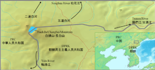
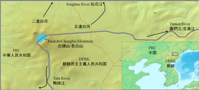
English: Approximate PRC-DPRK border around Baekdu-Changbai Mountain
日本語: 白頭山付近の中朝国境線 |
||||
| Dat | |||||
| Sous |
|
||||
| Kreyatè | Jjok |
Other maps:Google map Chosun Ilbo archive copy at the Wayback Machine
Kondisyon itlizasyon
Moi, en tant que détenteur des droits d’auteur sur cette œuvre, je la publie sous les licences suivantes :
Fichye sa a distribiye selon lisans Creative Commons.
- Ou gen dwa:
- pou pataje – pou kopye, distribiye epi difize ouvraj la
- pou remiks – pou adapte ouvraj la
- Selon kondisyon sa a yo:
- Rekonèt avèk non otè – Ou dwe bay enfòmasyon apwopriye sou otè a, bay yon lyen pou lisans lan, epi endike si te gen chanjman ki fèt. Ou ka fè sa nan nenpòt fason rezonab, men okenn fason ki sijere ke otè a soutni oswa apwouve itilizasyon ou an.
- Enfòmasyon sa yo ka pataje – Si ou fè rekopye, transfòme, oswa baze sou materyèl sa, ou dwe distribye kontribisyon ou anba menm oswa yon lisans konpatib avèk orijinal la.

|
Ou bay pèmisyon pou kopye, distribye ak/oswa modifye dokiman sa a dapre kondisyon GNU Free Documentation License, Vèsyon. 1.2 oswa nenpòt vèsyon ki pibliye pita pa Free Software Foundation; san okenn Seksyon ki pa ka chanje, pa gen okenn Tèks ak premye paj kouvèti, epi pa gen okenn Tèks Denyè-Kouvèti. Gen yon kopi lisans lan nan seksyon ki rele GNU Free Documentation License. |
Chwazi lisans ou vle a.
Istorik fichye a
Klike sou yon dat/yon lè pou wè fichye a jan li te ye nan moman sa a.
| Dat ak lè | Minyati | Grandè yo | Itilizatè | Komantè | |
|---|---|---|---|---|---|
| Kounye a | 7 desanm 2010 à 13:21 | | 1 877 × 849 (2,55 Mio) | Suzukitaro | add lines between the large scale map and the small scale map |
| 7 septanm 2010 à 03:37 |  | 1 877 × 849 (2,44 Mio) | Jjok | expanded the inset | |
| 7 septanm 2010 à 03:17 |  | 1 880 × 848 (2,45 Mio) | Jjok | added names and an inset | |
| 7 septanm 2010 à 03:14 |  | 1 469 × 657 (768 kio) | Jjok | {{Information |Description={{en|1=Approximate PRC-DPRK border around Baekdu-Changbai Mountain}} {{ja|1=白頭山付近の中朝国境線}} |Source={{Demis}} |Author=Jjok |Date=2010-09-06 |Permission= |other_versions= }} [http://maps.google.c |
Itilizasyon fichye sa a
Pa gen okenn paj ki itilize dosye sa a.
Itilizasyon global fichye a
Wiki sa a yo sèvi ak fichye sa a:
- Itilizasyon sou arz.wikipedia.org
- Itilizasyon sou bn.wikipedia.org
- Itilizasyon sou en.wikipedia.org
- Itilizasyon sou hi.wikipedia.org
- Itilizasyon sou hu.wikipedia.org
- Itilizasyon sou ja.wikipedia.org
- Itilizasyon sou ko.wikipedia.org
- Itilizasyon sou pa.wikipedia.org
- Itilizasyon sou pnb.wikipedia.org
- Itilizasyon sou pt.wikipedia.org
- Itilizasyon sou www.wikidata.org
- Itilizasyon sou zh.wikipedia.org