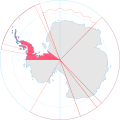
Fichye:Antarctica, Chile territorial claim.svg
Apparence

Taille de cet aperçu PNG pour ce fichier SVG : 600 × 600 piksèl. Lòt rezolisyon yo: 240 × 240 piksèl | 480 × 480 piksèl | 768 × 768 piksèl | 1 024 × 1 024 piksèl | 2 048 × 2 048 piksèl | 806 × 806 piksèl.
Fichye orijinal (Fichye SVG, rezolisyon de 806 × 806 piksèl, gwosè fichye : 63 kio)
Istorik fichye a
Klike sou yon dat/yon lè pou wè fichye a jan li te ye nan moman sa a.
| Dat ak lè | Minyati | Grandè yo | Itilizatè | Komantè | |
|---|---|---|---|---|---|
| Kounye a | 8 me 2020 à 17:07 |  | 806 × 806 (63 kio) | Spesh531 | Norway's claim extends south to the South Pole as of June 12 2015. Northern claim is still undefined |
| 30 jen 2008 à 20:55 |  | 806 × 806 (65 kio) | Lokal Profil | {{Information |Description={{en|Map showing the territorial claim to Antarctica by the country in the filename. Also on the map are is the 60° S Parallel, Antarctic Circle, 0/180 latitude line and (in red) the borders of the claims by other states.}} |So |
Itilizasyon fichye sa a
Pa gen okenn paj ki itilize dosye sa a.
Itilizasyon global fichye a
Wiki sa a yo sèvi ak fichye sa a:
- Itilizasyon sou af.wikipedia.org
- Itilizasyon sou an.wikipedia.org
- Itilizasyon sou ar.wikipedia.org
- Itilizasyon sou ast.wikipedia.org
- Itilizasyon sou az.wikipedia.org
- Itilizasyon sou ca.wikipedia.org
- Itilizasyon sou chr.wikipedia.org
- Itilizasyon sou ckb.wikipedia.org
- Itilizasyon sou cs.wikipedia.org
- Itilizasyon sou de.wikipedia.org
- Itilizasyon sou diq.wikipedia.org
- Itilizasyon sou el.wikipedia.org
- Itilizasyon sou en.wikipedia.org
- Itilizasyon sou et.wikipedia.org
- Itilizasyon sou fa.wikipedia.org
- Itilizasyon sou fi.wikipedia.org
- Itilizasyon sou frr.wikipedia.org
- Itilizasyon sou fr.wikipedia.org
- Itilizasyon sou gl.wikipedia.org
- Itilizasyon sou gv.wikipedia.org
- Itilizasyon sou hu.wikipedia.org
- Itilizasyon sou hy.wikipedia.org
- Itilizasyon sou id.wikipedia.org
- Itilizasyon sou ilo.wikipedia.org
- Itilizasyon sou it.wikipedia.org
- Itilizasyon sou ja.wikipedia.org
- Itilizasyon sou ko.wikipedia.org
Gade plis itilizasyon global fichye sa a.
