
Fichye:Aerial view of an Oyster Reef (22819976251).jpg

Dimansyon previzyalizasyon sa a : 800 × 533 piksèl. Lòt rezolisyon yo: 320 × 213 piksèl | 640 × 427 piksèl | 1 024 × 683 piksèl | 1 280 × 853 piksèl | 2 560 × 1 707 piksèl | 4 428 × 2 952 piksèl.
Fichye orijinal (4 428 × 2 952 piksèl, gwosè fichye a : 10,98 Mio, tip MIME li ye : image/jpeg)
.jpg)
Rezime
| Deskripsyon |
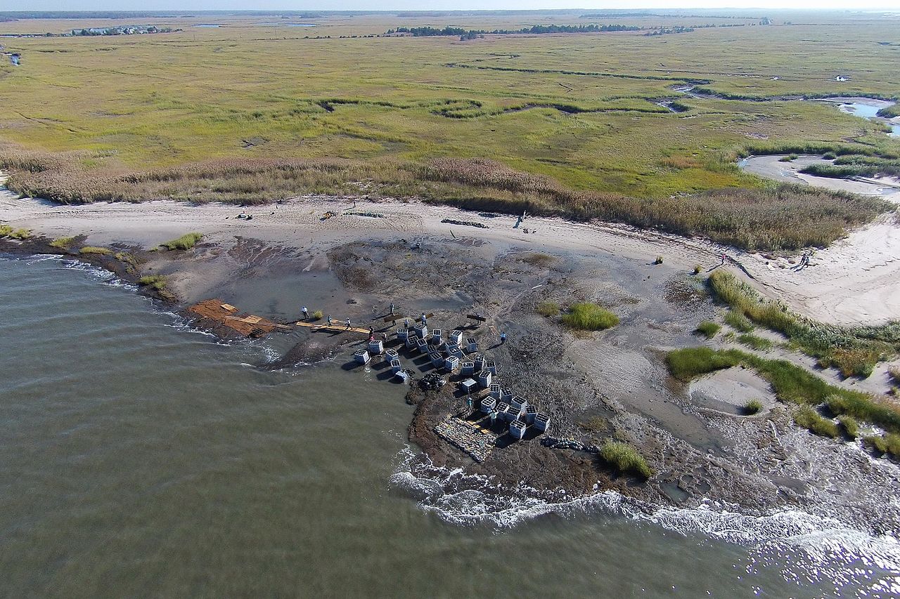
English: The first phase of the Hurricane Sandy-funded living shoreline installation in Downe Township, New Jersey, part of the Gandy’s Beach shoreline protection project, was completed in October 2015. For three days, partners and local volunteers placed a combination of “oyster castles” -- stackable, interlocking blocks of concrete, limestone, crushed shell and silica that encourage oyster larvae to settle -- and bagged oyster shells created by local schools, just offshore. Partner organizations will monitor the integrity of the structure through winter and apply findings to inform future reef installations in the same area next year. The work of this partnership will help stabilize approximately 3,000 feet of beach and tidal marsh shoreline, allowing the coast to heal itself.
|
| Dat | |
| Sous | https://www.flickr.com/photos/usfwsnortheast/22819976251/ |
| Kreyatè | U. S. Fish and Wildlife Service - Northeast Region |
| Pèmisyon : (Resèvi ak fichye sa a) |
At the time of upload, the image license was automatically confirmed using the Flickr API. For more information see Flickr API detail. |
| Flickr sets |
|
| Flickr tags |
|
| Lieu de la prise de vue | | Voir cet endroit et d’autres images sur : OpenStreetMap |
|---|
.jpg¶ms=039.278611_N_-075.243612_E_globe:Earth_type:camera__&language=ht)
Kondisyon itlizasyon
Ce fichier est disponible selon les termes de la licence Creative Commons Attribution 2.0 Générique.
- Ou gen dwa:
- pou pataje – pou kopye, distribiye epi difize ouvraj la
- pou remiks – pou adapte ouvraj la
- Selon kondisyon sa a yo:
- Rekonèt avèk non otè – Ou dwe bay enfòmasyon apwopriye sou otè a, bay yon lyen pou lisans lan, epi endike si te gen chanjman ki fèt. Ou ka fè sa nan nenpòt fason rezonab, men okenn fason ki sijere ke otè a soutni oswa apwouve itilizasyon ou an.
| Cette image a été originellement postée sur Flickr par U. S. Fish and Wildlife Service - Northeast Region à l'adresse https://flickr.com/photos/43322816@N08/22819976251. Elle a été passée en revue le 28 septanm 2016 par le robot FlickreviewR, qui a confirmé qu'elle se trouvait sous licence cc-by-2.0. |
Ce fichier est une œuvre d'un employé du U.S. Fish and Wildlife Service, réalisée dans le cadre de ses activités professionnelles. En tant qu'œuvre du gouvernement fédéral des États-Unis d'Amérique, cette image est placée dans le domaine public. Pour plus d'informations, consultez la politique des droits d'auteurs du Fish and Wildlife Service (en anglais).
|
 |
Istorik fichye a
Klike sou yon dat/yon lè pou wè fichye a jan li te ye nan moman sa a.
| Dat ak lè | Minyati | Grandè yo | Itilizatè | Komantè | |
|---|---|---|---|---|---|
| Kounye a | 28 septanm 2016 à 13:22 | | 4 428 × 2 952 (10,98 Mio) | Fæ | Flickr Set 72157644908524104, ID 22819976251, Original title Aerial view of an Oyster Reef |
Itilizasyon fichye sa a
paj sa a itilize fichye sa a:
Itilizasyon global fichye a
Wiki sa a yo sèvi ak fichye sa a:
- Itilizasyon sou cy.wikipedia.org
- Itilizasyon sou es.wikipedia.org
- Itilizasyon sou ky.wikipedia.org
- Itilizasyon sou uk.wikipedia.org
- Itilizasyon sou www.wikidata.org
.jpg)