
Fichye:Southampton-town-map.gif
Pa genyen rezolisyon ki pi wo ki disponib.
Southampton-town-map.gif (575 × 425 piksèl, gwosè fichye a : 34 kio, tip MIME li ye : image/gif)
Rezime
| Deskripsyon | |
| Dat | |
| Sous | http://factfinder.census.gov |
| Kreyatè | United States Census Bureau |
| Pèmisyon : (Resèvi ak fichye sa a) |
Public domain |
Kondisyon itlizasyon
This image or file is a work of a United States Census Bureau employee, taken or made as part of that person's official duties. As a work of the U.S. federal government, the image is in the public domain.
|
 |
Journal des téléversements d’origine
La page de description originale était ici. Tous les noms d'utilisateur qui suivent se rapportent à en.wikipedia.
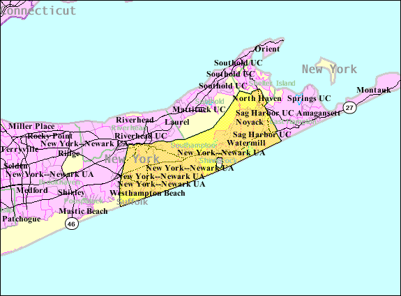
- 2007-10-22 08:29 Americasroof 575×425× (34945 bytes) [[Southampton (town), New York]] map from United States Census
Istorik fichye a
Klike sou yon dat/yon lè pou wè fichye a jan li te ye nan moman sa a.
| Dat ak lè | Minyati | Grandè yo | Itilizatè | Komantè | |
|---|---|---|---|---|---|
| Kounye a | 23 out 2013 à 05:04 | | 575 × 425 (34 kio) | Dcirovic | {{Information |Description={{en|en:U.S. Census 2000 reference map for en:Southampton (town), New York}} |Source=Transferred from [http://en.wikipedia.org en.wikipedia]<br/> (Original text : ''http://factfinder.census.gov'') |Date=2007<br/> ... |
Itilizasyon fichye sa a
paj sa a itilize fichye sa a:
Itilizasyon global fichye a
Wiki sa a yo sèvi ak fichye sa a:
- Itilizasyon sou arz.wikipedia.org
- Itilizasyon sou azb.wikipedia.org
- Itilizasyon sou cy.wikipedia.org
- Itilizasyon sou es.wikipedia.org
- Itilizasyon sou eu.wikipedia.org
- Itilizasyon sou fa.wikipedia.org
- Itilizasyon sou fr.wikipedia.org
- Itilizasyon sou it.wikipedia.org
- Itilizasyon sou nl.wikipedia.org
- Itilizasyon sou no.wikipedia.org
- Itilizasyon sou pl.wikipedia.org
- Itilizasyon sou sh.wikipedia.org
- Itilizasyon sou sr.wikipedia.org
- Itilizasyon sou tt.wikipedia.org
- Itilizasyon sou www.wikidata.org
- Itilizasyon sou zh.wikipedia.org