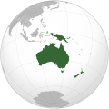
Fichye:Oceania (orthographic projection).svg

Taille de cet aperçu PNG pour ce fichier SVG : 541 × 541 piksèl. Lòt rezolisyon yo: 240 × 240 piksèl | 480 × 480 piksèl | 768 × 768 piksèl | 1 024 × 1 024 piksèl | 2 048 × 2 048 piksèl.
Fichye orijinal (Fichye SVG, rezolisyon de 541 × 541 piksèl, gwosè fichye : 63 kio)
Istorik fichye a
Klike sou yon dat/yon lè pou wè fichye a jan li te ye nan moman sa a.
| Dat ak lè | Minyati | Grandè yo | Itilizatè | Komantè | |
|---|---|---|---|---|---|
| Kounye a | 6 fevriye 2023 à 18:54 |  | 541 × 541 (63 kio) | Golden Mage | A change to the map of Asia will first face debate from others. Hence, a change to the commonly accepted map of Oceania cannot be made without a wider consensus. |
| 6 fevriye 2023 à 06:33 |  | 541 × 541 (108 kio) | Kwamikagami | rv: then perhaps we need to change the Asia map to match. This is as defined in WP. | |
| 5 fevriye 2023 à 18:19 |  | 541 × 541 (63 kio) | Golden Mage | Reverted to the map that displays the more accepted definition of Oceania's boundaries. Widely accepted geopolitical definitions take precedence over mere geographical ones. The map of the Wikipedia page for Asia already includes the Maluku Islands. | |
| 5 fevriye 2023 à 05:01 |  | 541 × 541 (108 kio) | Treetoes023 | Reverted to version as of 06:27, 24 December 2022 (UTC) | |
| 5 fevriye 2023 à 05:00 |  | 541 × 541 (63 kio) | Treetoes023 | Reverted to version as of 13:25, 31 December 2022 (UTC) | |
| 5 fevriye 2023 à 04:55 |  | 541 × 541 (108 kio) | Treetoes023 | Reverted to version as of 00:31, 4 December 2022 (UTC) | |
| 31 desanm 2022 à 13:25 |  | 541 × 541 (63 kio) | Golden Mage | Reverted to the map that displays the more accepted definition of Oceania's boundaries. Widely accepted geopolitical definitions take precedence over mere geographical ones. | |
| 24 desanm 2022 à 06:27 |  | 541 × 541 (108 kio) | Kwamikagami | Reverted to version as of 00:31, 4 December 2022 (UTC) definition per WP-en | |
| 22 desanm 2022 à 06:13 |  | 541 × 541 (63 kio) | Golden Mage | Reverted to the map that displays the more accepted definition of Oceania's boundaries. | |
| 4 desanm 2022 à 00:31 |  | 541 × 541 (108 kio) | Kwamikagami | the Weber line divides Oceanic from Asian Wallacea |
Itilizasyon fichye sa a
Pa gen okenn paj ki itilize dosye sa a.
Itilizasyon global fichye a
Wiki sa a yo sèvi ak fichye sa a:
- Itilizasyon sou ab.wikipedia.org
- Itilizasyon sou ady.wikipedia.org
- Itilizasyon sou af.wikipedia.org
- Afrika
- Asië
- Europa
- Kiribati
- Noord-Amerika
- Suid-Amerika
- Vanuatu
- Guam
- Nieu-Seeland
- Sjabloon:Kontinente
- Australië
- Nauru
- Wellington, Nieu-Seeland
- Hoofstad
- Lys van hoofstede
- Sjabloon:Lande van Oseanië
- Honolulu
- Antarktika
- Gondwana
- Eurasië
- Laurasië
- Kategorie:Lande in Oseanië
- Lys van lande
- Fidji
- Canberra
- Hawaii
- Lys van nasionale leuses
- Clipperton
- Oseanië
- Norfolkeiland
- Amerikas
- Tonga
- Tuvalu
- Sjabloon:Hoofstede in Oseanië
- Palau
- Australië (kontinent)
- Afrika-Eurasië
- Samoa
- Marshalleilande
- Salomonseilande
- Papoea-Nieu-Guinee
- Gefedereerde State van Mikronesië
- Nukuʻalofa
- Port Moresby
- Apia
- Funafuti
- Honiara
- Majuro
Gade plis itilizasyon global fichye sa a.

