
Fichye:Mason from the west.jpg
Dimansyon previzyalizasyon sa a : 800 × 600 piksèl. Lòt rezolisyon yo: 320 × 240 piksèl | 640 × 480 piksèl | 1 024 × 768 piksèl | 1 280 × 960 piksèl | 2 272 × 1 704 piksèl.
Fichye orijinal (2 272 × 1 704 piksèl, gwosè fichye a : 1,57 Mio, tip MIME li ye : image/jpeg)
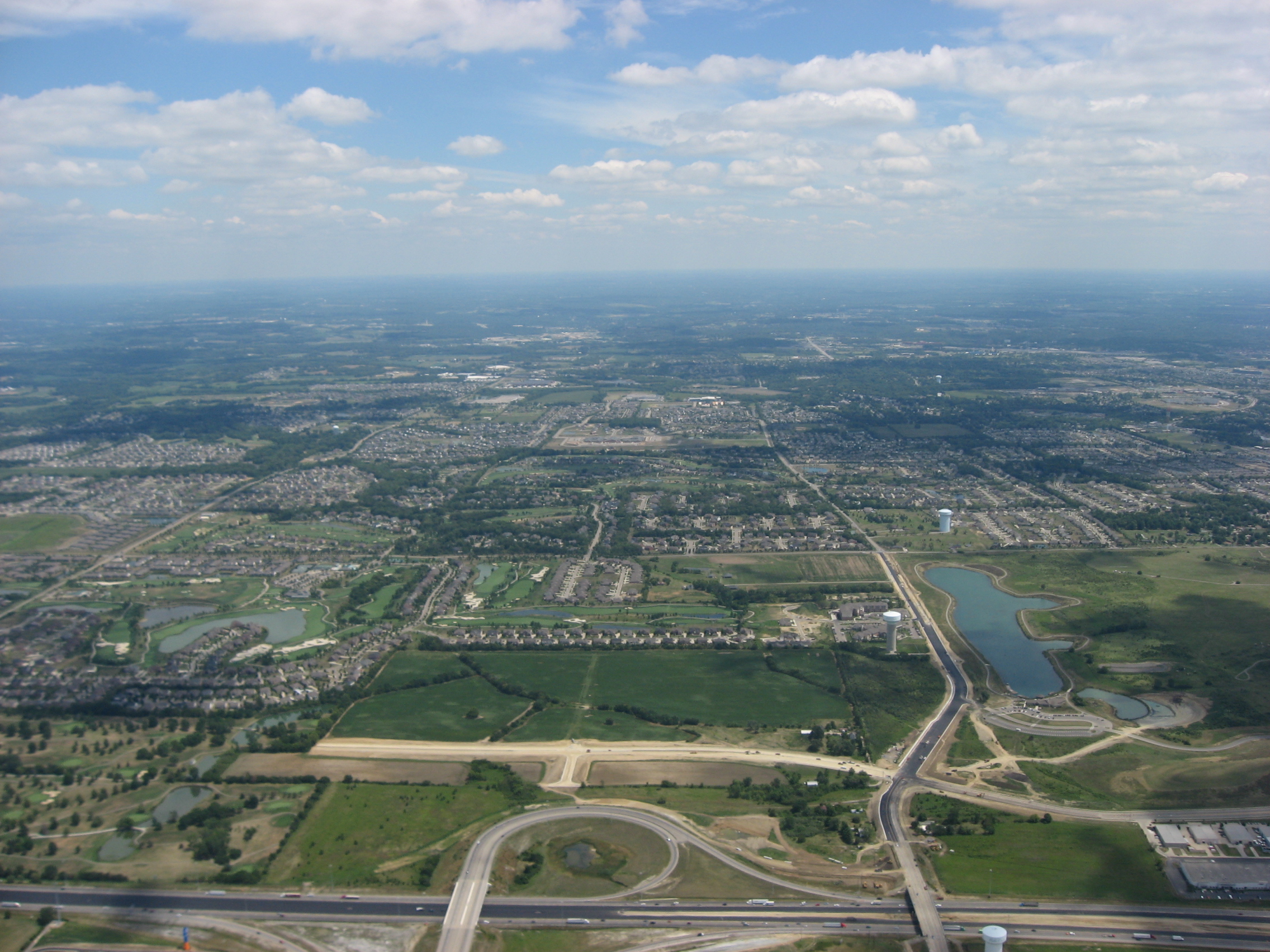
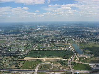
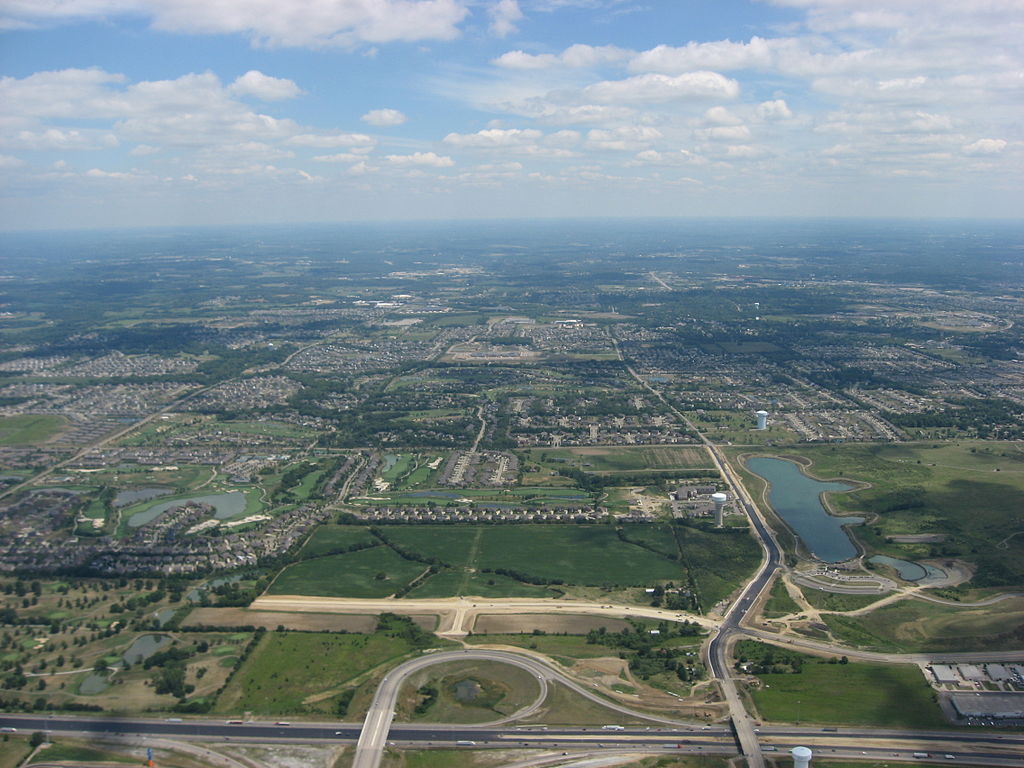
| Deskripsyon | Aerial view of Mason, a city in Warren County, Ohio, United States. Interstate 75 is visible along the bottom of the picture; its major interchange in the middle is the eastern end of State Route 129. Picture taken from a Diamond Eclipse light airplane at an altitude of 3,060 feet MSL and a bearing of approximately 95º. | ||
| Dat | Prise le 12 out 2008 | ||
| Sous | Travay pèsonèl | ||
| Kreyatè | Nyttend | ||
| Pèmisyon : (Resèvi ak fichye sa a) |
|
Istorik fichye a
Klike sou yon dat/yon lè pou wè fichye a jan li te ye nan moman sa a.
| Dat ak lè | Minyati | Grandè yo | Itilizatè | Komantè | |
|---|---|---|---|---|---|
| Kounye a | 19 septanm 2008 à 12:20 | | 2 272 × 1 704 (1,57 Mio) | Nyttend | {{Information |Description=Aerial view of {{w|Mason, Ohio|Mason}}, a city in {{w|Warren County, Ohio|Warren County}}, {{w|Ohio}}, {{w|United States}}. {{w|Interstate 75}} is visible along the bottom of the picture; its major interchange in the middle is |
Itilizasyon fichye sa a
paj sa a itilize fichye sa a:
Itilizasyon global fichye a
Wiki sa a yo sèvi ak fichye sa a:
- Itilizasyon sou ar.wikipedia.org
- Itilizasyon sou arz.wikipedia.org
- Itilizasyon sou azb.wikipedia.org
- Itilizasyon sou ca.wikipedia.org
- Itilizasyon sou ceb.wikipedia.org
- Itilizasyon sou ce.wikipedia.org
- Itilizasyon sou cy.wikipedia.org
- Itilizasyon sou de.wikipedia.org
- Itilizasyon sou en.wikipedia.org
- Itilizasyon sou en.wikinews.org
- Itilizasyon sou en.wikivoyage.org
- Itilizasyon sou es.wikipedia.org
- Itilizasyon sou eu.wikipedia.org
- Itilizasyon sou fa.wikipedia.org
- Itilizasyon sou fr.wikipedia.org
- Itilizasyon sou it.wikipedia.org
- Itilizasyon sou ky.wikipedia.org
- Itilizasyon sou la.wikipedia.org
- Itilizasyon sou lld.wikipedia.org
- Itilizasyon sou no.wikipedia.org
- Itilizasyon sou pl.wikipedia.org
- Itilizasyon sou pt.wikipedia.org
- Itilizasyon sou ro.wikipedia.org
- Itilizasyon sou ru.wikipedia.org
- Itilizasyon sou sh.wikipedia.org
- Itilizasyon sou simple.wikipedia.org
- Itilizasyon sou sr.wikipedia.org
- Itilizasyon sou sv.wikipedia.org
- Itilizasyon sou tr.wikipedia.org
- Itilizasyon sou tt.wikipedia.org
- Itilizasyon sou uk.wikipedia.org
- Itilizasyon sou ur.wikipedia.org
- Itilizasyon sou uz.wikipedia.org
- Itilizasyon sou vi.wikipedia.org
- Itilizasyon sou vo.wikipedia.org
- Itilizasyon sou www.wikidata.org
- Itilizasyon sou zh-min-nan.wikipedia.org
- Itilizasyon sou zh.wikipedia.org