Aller au contenu

Fichye:Japanese Empire (orthographic projection).svg

Le contenu de la page n’est pas pris en charge dans d’autres langues.
Depi Wikipedya, ansiklopedi lib

Fichye orijinal (Fichye SVG, rezolisyon de 600 × 600 piksèl, gwosè fichye : 665 kio)

Fichye sa a sòti nan Wikimedia Commons e ka sèvi nan lòt pwojè. Desktripsyon ki sou paj li file description page ekri anba a.

Rezime

Deskripsyon
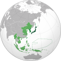
English: Japanese Empire.
 
Territory (1870–1895).
 
Acquisitions (1895–1930).
 
Acquisitions (1930–1942).
 
South Seas Mandate (1919–1947).
Español: Imperio Japonés.
 
Territorio (1870–1895).
 
Adquisiciones (1895–1930)
 
Adquisiciones (1930–1942).
 
Mandato del Pacífico Sur (1919–1947).
Українська: Японська імперія.
 
Територія (1870–1895).
 
Нові території (1895–1930).
 
Нові території (1930–1942).
 
Південний Тихоокеанський мандат (1919–1947).
日本語: 大日本帝国
 
日本 (1870–1895)
 
朝鮮、台湾 (1895–1930)
 
占領地 (1930–1942)
 
委任統治地域南洋群島 (1919–1947)
Dat (UTC)
Sous
Kreyatè Milenioscuro
Autres versions
This is a Grey & green orthographic projection map.
العربية: الرجاء، قراءة الميثاق.
বাংলা: দয়া করে, রীতিনীতিটি পড়ুন
Deutsch: Bitte lies die Konventionen.
English: Please, read the conventions.
Español: Por favor, lea las convenciones.
Filipino: Paki-basa ang mga kumbensyon.
Français : S'il vous plaît, lisez les conventions.
हिन्दी: कृपया सभागमों को पढ़ लें.
Bahasa Indonesia: Silakan, baca konvensi.
Italiano: Si prega di leggere le convenzioni.
日本語: 規約をご確認ください。
ქართული: გთხოვთ, გაეცნოთ კონვენციებს.
Português: Por favor, leia as convenções.
Русский: Пожалуйста, прочитайте соглашения.
Українська: Будь ласка, прочитайте конвенції.
Tiếng Việt: Hãy đọc công văn trước khi đăng.
中文(繁體):請檢視常規
中文(简体):请查看常规
World maps

Africa

हिन्दी: अफ्रीका
ქართული: აფრიკა.

Eastern Africa

Southern Africa

Central Africa

Northern Africa

Western Africa

Americas

ქართული: ამერიკა.
हिन्दी: अमेरिका

North America

Central America

Caribbean

South America

Asia

ქართული: აზია.
Português: Ásia.
Українська: Азія.

East

Português: Ásia Oriental.
Українська: Східна Азія.

Central

हिन्दी: मध्य एशिया
Português: Ásia Central.
Українська: Центральна Азія.

Southeast

Bahasa Indonesia: Asia tenggara
Português: Sudeste Asiático.

South

(भारतीय उपमहाद्वीप)
Português: Sul da Ásia.
Українська: Південна Азія.

Western

Português: Sudoeste da Ásia.
Українська: Передня Азія.

Europe

हिन्दी: यूरोप
ქართული: ევროპა.
Português: Europa.
Română: Europa.
Русский: Европа.
Українська: Європа.

Countries

Oceania

हिन्दी: ओशिआनिया
ქართული: ოკეანეთი.
Português: Oceania.
Українська: Океанія.

Intercontinental

Português: Intercontinental.
Українська: Міжконтинентальні.

Historical

English: Unions, Organizations, Kingdoms, Empires
Español: Uniones, Organizaciones, Reinos, Imperios
Filipino: Mga Unyon, Organisasyon, Kaharian, Imperyo
Français : Unions, Organisations, Royaumes, Empires
हिन्दी: संघ, संगठन, राज्य, साम्राज्य व ऐतिहासिक देश
ქართული: გაერთიანებები, ორგანიზაციები, სამეფოები, იმპერიები
Português: Estados extintos.
Tagalog: Mga Unyon, Organisasyon, Kaharian, Imperyo
Українська: Союзи, Організації, Королівства, Імперії
中文(繁體):聯盟、組織、王國和帝國
中文(简体):联盟、组织、王国和帝国

Subnationals

हिन्दी: उपराष्ट्रीय इकाईयाँ
SVG information
InfoField
 
Le code de ce fichier SVG est valide.
 
Cette carte a été créée avec Inkscape.

Kondisyon itlizasyon

Moi, en tant que détenteur des droits d’auteur sur cette œuvre, je la publie sous les licences suivantes :
GNU head Ou bay pèmisyon pou kopye, distribye ak/oswa modifye dokiman sa a dapre kondisyon GNU Free Documentation License, Vèsyon. 1.2 oswa nenpòt vèsyon ki pibliye pita pa Free Software Foundation; san okenn Seksyon ki pa ka chanje, pa gen okenn Tèks ak premye paj kouvèti, epi pa gen okenn Tèks Denyè-Kouvèti. Gen yon kopi lisans lan nan seksyon ki rele GNU Free Documentation License.
w:fr:Creative Commons
Rekonèt avèk non otè Enfòmasyon sa yo ka pataje
Fichye sa a distribiye selon lisans Creative Commons.
Ou gen dwa:
  • pou pataje – pou kopye, distribiye epi difize ouvraj la
  • pou remiks – pou adapte ouvraj la
Selon kondisyon sa a yo:
  • Rekonèt avèk non otè – Ou dwe bay enfòmasyon apwopriye sou otè a, bay yon lyen pou lisans lan, epi endike si te gen chanjman ki fèt. Ou ka fè sa nan nenpòt fason rezonab, men okenn fason ki sijere ke otè a soutni oswa apwouve itilizasyon ou an.
  • Enfòmasyon sa yo ka pataje – Si ou fè rekopye, transfòme, oswa baze sou materyèl sa, ou dwe distribye kontribisyon ou anba menm oswa yon lisans konpatib avèk orijinal la.
Chwazi lisans ou vle a.

Journal des téléversements d’origine

This image is a travail dérivé of the following images:

Téléversé avec derivativeFX

Légendes

Ajoutez en une ligne la description de ce que représente ce fichier
This map represents the Japanese empire. It contains a mistake: new Caledonia was never conquered by Japan.

Éléments décrits dans ce fichier

penn

type MIME français

image/svg+xml

Istorik fichye a

Klike sou yon dat/yon lè pou wè fichye a jan li te ye nan moman sa a.

(anpil resan | anpil vye) Gade (10 ki fèk fèt yo | ) (10 | 20 | 50 | 100 | 250 | 500)
Dat ak lèMinyatiGrandè yoItilizatèKomantè
Kounye a14 jen 2023 à 03:45Minyati pou vèsyon 14 jen 2023 à 03:45600 × 600 (665 kio)BankliveReverted to version as of 04:21, 2 May 2022 (UTC) treaty between thailand and japan 1940. The treaty should be used as a reference. The same standard as Switzerland in Europe.
21 avril 2023 à 14:54Minyati pou vèsyon 21 avril 2023 à 14:54600 × 600 (797 kio)LCJapan2034Reverted to version as of 19:32, 15 June 2021 (UTC)
2 me 2022 à 04:21Minyati pou vèsyon 2 me 2022 à 04:21600 × 600 (665 kio)TheMysteriousStarReverted to version as of 12:51, 14 June 2021 (UTC) Japan never controlled Thailand
15 jen 2021 à 19:32Minyati pou vèsyon 15 jen 2021 à 19:32600 × 600 (797 kio)MilenioscuroReverted to version as of 21:19, 16 April 2021 (UTC)
14 jen 2021 à 12:51Minyati pou vèsyon 14 jen 2021 à 12:51600 × 600 (665 kio)CommymonoReverted to version as of 11:13, 23 January 2015 (UTC)
16 avril 2021 à 21:19Minyati pou vèsyon 16 avril 2021 à 21:19600 × 600 (797 kio)Milenioscurocorrected size of Dalian/Port Arthur
14 novanm 2020 à 21:42Minyati pou vèsyon 14 novanm 2020 à 21:42600 × 600 (847 kio)Milenioscuroresolving some really, really, REALLY bad editions of this guys
6 out 2020 à 16:19Minyati pou vèsyon 6 out 2020 à 16:19600 × 600 (1,37 Mio)Hell - llliobetter borders, added christimas, spratly and paracel islands.
6 jiyè 2020 à 18:07Minyati pou vèsyon 6 jiyè 2020 à 18:07600 × 600 (1,24 Mio)Hell - lllioFixed Borders in South Yunnan, added Guam, Bonin Islands, Volcano Islands, Wake Islands, Gilbert Islands, Minami-Tori-shima, Okinotorishima and Pescadores.
5 jiyè 2020 à 20:08Minyati pou vèsyon 5 jiyè 2020 à 20:08600 × 600 (1,24 Mio)Hell - lllioadded Thailand (Under Massive Japanese Influence), Attu and Kiska (Aleutian Islands Campaign) and Parts on the South of the Yunnan Region.
(anpil resan | anpil vye) Gade (10 ki fèk fèt yo | ) (10 | 20 | 50 | 100 | 250 | 500)

Pa gen okenn paj ki itilize dosye sa a.

Itilizasyon global fichye a

Wiki sa a yo sèvi ak fichye sa a:

Gade plis itilizasyon global fichye sa a.

Metadone