
Fichye:Illinois Traction System Minooka Passenger Station.jpg

Dimansyon previzyalizasyon sa a : 800 × 597 piksèl. Lòt rezolisyon yo: 320 × 239 piksèl | 640 × 478 piksèl | 1 024 × 765 piksèl | 1 280 × 956 piksèl | 2 560 × 1 911 piksèl | 4 721 × 3 525 piksèl.
Fichye orijinal (4 721 × 3 525 piksèl, gwosè fichye a : 2,35 Mio, tip MIME li ye : image/jpeg)
| Deskripsyon |
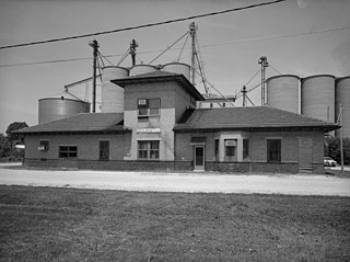
Illinois Traction System, Minooka Passenger Station, Minooka, Grundy County, IL. |
|||||||||||||||||||||||
| Dat | ||||||||||||||||||||||||
| Sous |
Historic American Buildings Survey HAER ILL, 32-MINK, 1-1
|
|||||||||||||||||||||||
| Kreyatè |
|
|||||||||||||||||||||||
| Pèmisyon : (Resèvi ak fichye sa a) |
|
|||||||||||||||||||||||

.jpg)
| Position de l'objet | | Voir cet endroit et d’autres images sur : OpenStreetMap |
|---|
Istorik fichye a
Klike sou yon dat/yon lè pou wè fichye a jan li te ye nan moman sa a.
| Dat ak lè | Minyati | Grandè yo | Itilizatè | Komantè | |
|---|---|---|---|---|---|
| Kounye a | 12 avril 2008 à 22:35 | | 4 721 × 3 525 (2,35 Mio) | Finavon | border cropped |
| 31 mas 2007 à 00:19 |  | 5 000 × 4 013 (2,54 Mio) | Dual Freq | {{Information |Description=Illinois Traction System, Minooka Passenger Station, Minooka, Grundy County, IL. (1. SOUTH FACADE OF STATION LOOKING NORTHWEST. HAER ILL, 32-MINK, 1-1) |Source=[http://memory.loc.gov/pnp/habshaer/il/il0600/il0650/photos/037235pu |
Itilizasyon fichye sa a
paj sa a itilize fichye sa a:
Itilizasyon global fichye a
Wiki sa a yo sèvi ak fichye sa a:
- Itilizasyon sou ar.wikipedia.org
- Itilizasyon sou ca.wikipedia.org
- Itilizasyon sou ceb.wikipedia.org
- Itilizasyon sou cy.wikipedia.org
- Itilizasyon sou en.wikipedia.org
- Itilizasyon sou es.wikipedia.org
- Itilizasyon sou eu.wikipedia.org
- Itilizasyon sou fr.wikipedia.org
- Itilizasyon sou it.wikipedia.org
- Itilizasyon sou lld.wikipedia.org
- Itilizasyon sou pl.wikipedia.org
- Itilizasyon sou pt.wikipedia.org
- Itilizasyon sou sh.wikipedia.org
- Itilizasyon sou sr.wikipedia.org
- Itilizasyon sou uk.wikipedia.org
- Itilizasyon sou vi.wikipedia.org
- Itilizasyon sou www.wikidata.org
- Itilizasyon sou zh-min-nan.wikipedia.org
- Itilizasyon sou zh.wikipedia.org