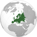
Fichye:Europe (orthographic projection).svg

Fichye orijinal (Fichye SVG, rezolisyon de 541 × 541 piksèl, gwosè fichye : 239 kio)
Fichye sa a sòti nan Wikimedia Commons e ka sèvi nan lòt pwojè. Desktripsyon ki sou paj li file description page ekri anba a.
Rezime
| DeskripsyonEurope (orthographic projection).svg |
العربية: الخريطة الهجائية لأوروبا English: Europe
Français : Europe ქართული: ევროპა |
||||
| Dat | |||||
| Sous |
Travay pèsonèl
|
||||
| Kreyatè | Ssolbergj | ||||
| Autres versions |
Œuvres dérivées de ce fichier : Europe orthographic Caucasus Urals boundary.svg العربية: الرجاء، قراءة الميثاق.
বাংলা: দয়া করে, রীতিনীতিটি পড়ুন।
Deutsch: Bitte lies die Konventionen.
English: Please, read the conventions.
Español: Por favor, lea las convenciones.
Filipino: Paki-basa ang mga kumbensyon.
Français : S'il vous plaît, lisez les conventions.
हिन्दी: कृपया सभागमों को पढ़ लें.
Bahasa Indonesia: Silakan, baca konvensi.
Italiano: Si prega di leggere le convenzioni.
日本語: 規約をご確認ください。
ქართული: გთხოვთ, გაეცნოთ კონვენციებს.
Македонски: Ве молиме, прочитајте ги општоприфатените правила.
Português: Por favor, leia as convenções.
Русский: Пожалуйста, прочитайте соглашения.
Tagalog: Paki-basa ang mga kumbensyon.
Українська: Будь ласка, прочитайте конвенції.
Tiếng Việt: Hãy đọc công văn trước khi đăng.
|
||||
| SVG information InfoField | Le code de ce fichier SVG n'est pas valide en raison de 98 erreurs. Cette carte SVG utilise du texte encapsulé qui peut être traduit facilement à l'aide d'un éditeur de texte. |
Kondisyon itlizasyon
| Public domainPublic domainfalsefalse |
| This map is ineligible for copyright and therefore in the public domain, because it consists entirely of information that is common property and contains no original authorship. For more information, see Commons:Threshold of originality § Maps.
English | Español | Galego | Română | slovenščina | العربية | 中文 | +/− |
| Annotations InfoField | Cette image est annotée : Voir les annotations sur Wikimedia Commons |
Poland
Spain
Portugal
Africa
Asia
Norway
France
Italy
America
Moldova
United Kingdom
Russia
Ireland
Greece
Finland
Germany
Denmark
Corsica
Switzerland
Bulgaria
Iceland
Sicilia
Cyprus
Malta
Estonia
Svalbard
Greenland
Sardinia
Albania
Austria
Balearic Islands
Crete
Légendes
créé par français
Valeur sans élément de Wikidata
statut des droits d'auteur français
sous droit d'auteur français
licence français
Licence de documentation libre GNU français
date de fondation ou de création français
7 janvye 2009
type MIME français
image/svg+xml
Istorik fichye a
Klike sou yon dat/yon lè pou wè fichye a jan li te ye nan moman sa a.
| Dat ak lè | Minyati | Grandè yo | Itilizatè | Komantè | |
|---|---|---|---|---|---|
| Kounye a | 31 janvye 2016 à 09:46 |  | 541 × 541 (239 kio) | Christina1969 | Reverted to version as of 19:08, 20 June 2009 (UTC) |
| 8 septanm 2013 à 20:21 |  | 541 × 541 (235 kio) | Chipmunkdavis | Reverted to version as of 22:37, 8 July 2009 Restore to version which notes source | |
| 12 septanm 2012 à 20:11 |  | 541 × 541 (82 kio) | Palosirkka | Scrubbed with http://codedread.com/scour/ | |
| 4 avril 2011 à 18:44 |  | 541 × 541 (235 kio) | Green, White and Gold | Reverted to version as of 22:37, 8 July 2009 | |
| 3 avril 2011 à 04:49 |  | 541 × 541 (239 kio) | ComtesseDeMingrelie | correcting Phasis riverbank | |
| 3 avril 2011 à 04:49 |  | 541 × 541 (235 kio) | ComtesseDeMingrelie | more common | |
| 3 avril 2011 à 04:44 |  | 541 × 541 (235 kio) | ComtesseDeMingrelie | most common definition | |
| 8 jiyè 2009 à 22:37 |  | 541 × 541 (235 kio) | Bosonic dressing | rv: yes - per Natl Geographic Atlas of the World, which trumps what might be an original concoction | |
| 5 jiyè 2009 à 13:50 |  | 541 × 541 (235 kio) | Ssolbergj | I based the border on http://en.wikipedia.org/wiki/File:Map_of_Europe_(political).png. Do you have a more reliable source? | |
| 20 jen 2009 à 19:08 |  | 541 × 541 (239 kio) | Bosonic dressing | Europe: orthographic projection - minor tweak of continental border in Caucasus |
Itilizasyon fichye sa a
Pa gen okenn paj ki itilize dosye sa a.
Itilizasyon global fichye a
Wiki sa a yo sèvi ak fichye sa a:
- Itilizasyon sou ace.wikipedia.org
- Itali
- Peurancih
- Siprus
- Turuki
- Vatikan
- Iërupa
- Jeureuman
- Rumania
- Hongaria
- Polandia
- Moldova
- Austria
- Bèlgia
- Liechtenstein
- Luksèmburg
- Monakô
- Blanda
- Swiss
- Bèlarusia
- Bulgaria
- Ukraina
- Slowakia
- Rusia
- Denmark
- Swèdia
- Irlandia
- Islandia
- Latvia
- Lithuania
- Finlandia
- Èstonia
- Albania
- Andorra
- Bosnia Hèrzègovina
- Kroasia
- Malta
- Yunani
- Seupanyo
- Sèrbia
- San Marino
- Portugéh
- Monténègrô
- Slovenia
- Norwègia
- Cèkia
- Pola:Iërupa
- Kosovô
- Itilizasyon sou af.wikipedia.org
Gade plis itilizasyon global fichye sa a.
Metadone
Fichye sa genyen enfòmasyon adisyonèl, petèt ki soti nan yon kamera dijital oubyen yon nimerizè itilize pou kreye oubyen dijitalize li. Si fichye sa te modifye depi kreyasyon li, kèk detay ka pa menm avèk original la.
| Largeur | 541.47876 |
|---|---|
| Hauteur | 541.47876 |


