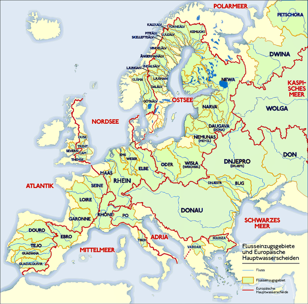
Fichye:Europäische Wasserscheiden.png
Le contenu de la page n’est pas pris en charge dans d’autres langues.
Depi Wikipedya, ansiklopedi lib

Fichye orijinal(1 200 × 1 184 piksèl, gwosè fichye a : 526 kio, tip MIME li ye : image/png)

Fichye sa a sòti nan Wikimedia Commons e ka sèvi nan lòt pwojè. Desktripsyon ki sou paj li file description page ekri anba a.

Rezime

Deskripsyon
Deutsch: Grafik zeigt die Europäischen Flusseinzugsgebiete und Hauptwasserscheiden.

Zeichnung erstellt 06/2004 von Sansculotte. Bild ist unter der Creative Commons Share Alike zur weiteren Verwendung freigegeben.

Quellenangabe und Beleg an sansculotte@despammed.com erbeten.
English: The map shows the European rivers' catchment areas and main watersheds.

Chart made on 06/2004 by de:Sansculotte. The image is released under the Creative Commons Share Alike license for futher use.

Reference and sources can be requested from sansculotte@despammed.com
Français : Carte des bassins fluviaux d'Europe. Carte établie en juin 2004 par le contributeur de:Sansculotte

Sources (!) disponibles par demande à sansculotte@despammed.com

  • Fluß = River = Fleuve
  • Flußeinzugsgebiet = River drainage basin = Bassin fluvial
  • Europäische Hauptwassercheide = European main drainage divides (GB: watersheds)
Dat
Sous Source: German Wikipedia, original upload see file history
Kreyatè Sansculotte
Pèmisyon :
(Resèvi ak fichye sa a)
w:fr:Creative Commons
Rekonèt avèk non otè Enfòmasyon sa yo ka pataje
Ou gen dwa:
  • pou pataje – pou kopye, distribiye epi difize ouvraj la
  • pou remiks – pou adapte ouvraj la
Selon kondisyon sa a yo:
  • Rekonèt avèk non otè – Ou dwe bay enfòmasyon apwopriye sou otè a, bay yon lyen pou lisans lan, epi endike si te gen chanjman ki fèt. Ou ka fè sa nan nenpòt fason rezonab, men okenn fason ki sijere ke otè a soutni oswa apwouve itilizasyon ou an.
  • Enfòmasyon sa yo ka pataje – Si ou fè rekopye, transfòme, oswa baze sou materyèl sa, ou dwe distribye kontribisyon ou anba menm oswa yon lisans konpatib avèk orijinal la.
GNU head Ou bay pèmisyon pou kopye, distribye ak/oswa modifye dokiman sa a dapre kondisyon GNU Free Documentation License, Vèsyon. 1.2 oswa nenpòt vèsyon ki pibliye pita pa Free Software Foundation; san okenn Seksyon ki pa ka chanje, pa gen okenn Tèks ak premye paj kouvèti, epi pa gen okenn Tèks Denyè-Kouvèti. Gen yon kopi lisans lan nan seksyon ki rele GNU Free Documentation License.
w:fr:Creative Commons
Rekonèt avèk non otè Enfòmasyon sa yo ka pataje
Fichye sa a distribiye selon lisans Creative Commons.
Ou gen dwa:
  • pou pataje – pou kopye, distribiye epi difize ouvraj la
  • pou remiks – pou adapte ouvraj la
Selon kondisyon sa a yo:
  • Rekonèt avèk non otè – Ou dwe bay enfòmasyon apwopriye sou otè a, bay yon lyen pou lisans lan, epi endike si te gen chanjman ki fèt. Ou ka fè sa nan nenpòt fason rezonab, men okenn fason ki sijere ke otè a soutni oswa apwouve itilizasyon ou an.
  • Enfòmasyon sa yo ka pataje – Si ou fè rekopye, transfòme, oswa baze sou materyèl sa, ou dwe distribye kontribisyon ou anba menm oswa yon lisans konpatib avèk orijinal la.
Ce bandeau de licence a été ajouté à ce fichier dans le cadre de la procédure de mise à jour des licences des images sous GFDL.
Autres versions

Derivative works of this file:

Cette image (de type geology) devrait être recréée dans un format vectoriel, en tant que fichier SVG. Cela offrirait plusieurs avantages : voir Commons:Media for cleanup pour plus d'informations. Si une version SVG de cette image est déjà disponible, merci de bien vouloir l'envoyer. Après cela, remplacez ce modèle par {{vector version available|nouveau nom d'image.svg}}.

Wikipedya

 Ceci est une image remarquable sur la Wikipédia en allemand (Exzellente Bilder) et est considéré(e) comme l'une de nos meilleures images.

Si vous pensez que ce fichier doit être une Image remarquable de
Wikimedia Commons
, vous pouvez le proposer.

Si vous avez une image de qualité similaire qui peut être publiée sous une licence compatible, vous pouvez l’importer, y apposer le bandeau de licence adéquat, et la proposer.

File history German Wikipedia

(Löschen) (Aktuell) 16:54, 15. Jan 2005 . . Sansculotte . . 1200x1184 (602233 Byte) (korr.)
(Löschen) (Zurücksetzen) 05:01, 3. Jun 2004 . . Sansculotte . . 1000x987 (262710 Byte) (eigene Darstellung, GNU FDL, Europäische Flußeinzugsgebiete und Hauptwasserscheiden)
(Löschen) (Zurücksetzen) 04:21, 3. Jun 2004 . . Sansculotte . . 1000x987 (183238 Byte) (eigene Darstellung, GNU FDL, Europäische Flußeinzugsgebiete und Hauptwasserscheiden)

Légendes

Ajoutez en une ligne la description de ce que représente ce fichier
The main rivers of Europe and their catchment areas.

Éléments décrits dans ce fichier

dépeint français

type MIME français

image/png

Istorik fichye a

Klike sou yon dat/yon lè pou wè fichye a jan li te ye nan moman sa a.

(anpil resan | anpil vye) Gade (10 ki fèk fèt yo | ) (10 | 20 | 50 | 100 | 250 | 500)
Dat ak lèMinyatiGrandè yoItilizatèKomantè
Kounye a31 jiyè 2019 à 08:45Minyati pou vèsyon 31 jiyè 2019 à 08:451 200 × 1 184 (526 kio)1970geminientschleiert
16 me 2016 à 01:21Minyati pou vèsyon 16 me 2016 à 01:211 200 × 1 184 (279 kio)Ulamm- Klare Farben für klar eInformationen - Ladogasee und finnische Flüsse nachgetragen - Wasser aus den Kattegat-Zuflüssen fließt nicht in die Ostsee; Zuordnung des Kattegat zur Ostsee nautisch und mangels eigener Meereseinheit
16 janvye 2016 à 22:03Minyati pou vèsyon 16 janvye 2016 à 22:031 200 × 1 184 (766 kio)Francis McLloydGrenzen in Südschweden, im Osten von Dänemark und westliche Ostsee ergänzt (jetzt)
16 janvye 2016 à 21:59Minyati pou vèsyon 16 janvye 2016 à 21:591 200 × 1 184 (763 kio)Francis McLloydGrenzen in Südschweden, im Osten von Dänemark und westliche Ostsee ergänzt
16 janvye 2016 à 20:21Minyati pou vèsyon 16 janvye 2016 à 20:211 200 × 1 184 (760 kio)Francis McLloydGrenze im Nord-Osten zwischen Newa und Kemijoki verbessert. Gebiete westlich des Newas hinzugefügt.
11 mas 2011 à 19:12Minyati pou vèsyon 11 mas 2011 à 19:121 200 × 1 184 (723 kio)W like wikia small part of the Adria-Mittelmeer drainage was missing. But i don t have time to check exactly, thats why only doted line.
11 mas 2011 à 18:14Minyati pou vèsyon 11 mas 2011 à 18:141 200 × 1 184 (724 kio)W like wikiDrainage divide in Italy, Denmark, UK and Gibraltar corrected. By the way: If someone have time and a better map than me, the doted line in Finnland should be replaced by "full line".
7 janvye 2011 à 13:59Minyati pou vèsyon 7 janvye 2011 à 13:591 200 × 1 184 (849 kio)CareSaimaa fix
24 fevriye 2010 à 14:44Minyati pou vèsyon 24 fevriye 2010 à 14:441 200 × 1 184 (564 kio)DcoetzeeRemove watermark, pngcrush
2 jiyè 2009 à 19:26Minyati pou vèsyon 2 jiyè 2009 à 19:261 200 × 1 184 (552 kio)NordNordWestDanube corrected, plus names of Vardar and Mariza
(anpil resan | anpil vye) Gade (10 ki fèk fèt yo | ) (10 | 20 | 50 | 100 | 250 | 500)

paj sa a itilize fichye sa a:

Itilizasyon global fichye a

Wiki sa a yo sèvi ak fichye sa a:

Gade plis itilizasyon global fichye sa a.