
Fichye:CAMap-doton-Oxnard.PNG
Pa genyen rezolisyon ki pi wo ki disponib.
CAMap-doton-Oxnard.PNG (209 × 230 piksèl, gwosè fichye a : 5 kio, tip MIME li ye : image/png)

|
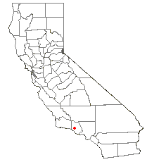
Cette image (de type locator map) devrait être recréée dans un format vectoriel, en tant que fichier SVG. Cela offrirait plusieurs avantages : voir Commons:Media for cleanup pour plus d'informations. Si une version SVG de cette image est déjà disponible, merci de bien vouloir l'envoyer. Après cela, remplacez ce modèle par {{vector version available|nouveau nom d'image.svg}}.
|
Locator maps U.S. cities derived from PD state maps by different users from en.wikipedia.
the filename has sometimes been adapted to the general syntax

|
Ou bay pèmisyon pou kopye, distribye ak/oswa modifye dokiman sa a dapre kondisyon GNU Free Documentation License, Vèsyon. 1.2 oswa nenpòt vèsyon ki pibliye pita pa Free Software Foundation; san okenn Seksyon ki pa ka chanje, pa gen okenn Tèks ak premye paj kouvèti, epi pa gen okenn Tèks Denyè-Kouvèti. Gen yon kopi lisans lan nan seksyon ki rele GNU Free Documentation License. |
| Fichye sa a distribiye selon lisans Creative Commons. | ||
| ||
| Ce bandeau de licence a été ajouté à ce fichier dans le cadre de la procédure de mise à jour des licences des images sous GFDL. |
Istorik fichye a
Klike sou yon dat/yon lè pou wè fichye a jan li te ye nan moman sa a.
| Dat ak lè | Minyati | Grandè yo | Itilizatè | Komantè | |
|---|---|---|---|---|---|
| Kounye a | 10 fevriye 2006 à 21:53 | | 209 × 230 (5 kio) | Michiel1972 | Locator maps U.S. cities derived from PD state maps by different users from en.wikipedia. <small>the filename has sometimes been adapted to the general syntax</small> {{GFDL}} category:Location maps of U.S. cities |
Itilizasyon fichye sa a
paj sa a itilize fichye sa a:
Itilizasyon global fichye a
Wiki sa a yo sèvi ak fichye sa a:
- Itilizasyon sou ang.wikipedia.org
- Itilizasyon sou ar.wikipedia.org
- Itilizasyon sou arz.wikipedia.org
- Itilizasyon sou ca.wikipedia.org
- Itilizasyon sou ceb.wikipedia.org
- Itilizasyon sou eo.wikipedia.org
- Itilizasyon sou eu.wikipedia.org
- Itilizasyon sou fr.wikipedia.org
- Itilizasyon sou ga.wikipedia.org
- Itilizasyon sou hu.wikipedia.org
- Itilizasyon sou nl.wikipedia.org
- Itilizasyon sou ro.wikipedia.org
- Itilizasyon sou tt.wikipedia.org
- Itilizasyon sou vo.wikipedia.org
- Itilizasyon sou www.wikidata.org