
Fichye:Belmont Ohio Historic District.jpg

Dimansyon previzyalizasyon sa a : 800 × 571 piksèl. Lòt rezolisyon yo: 320 × 228 piksèl | 640 × 457 piksèl | 1 024 × 731 piksèl | 1 340 × 956 piksèl.
Fichye orijinal (1 340 × 956 piksèl, gwosè fichye a : 172 kio, tip MIME li ye : image/jpeg)
|
Ceci est une photographie d’un monument référencé dans le National Register of Historic Places des États-Unis sous le numéro 87000422. |
| Deskripsyon |
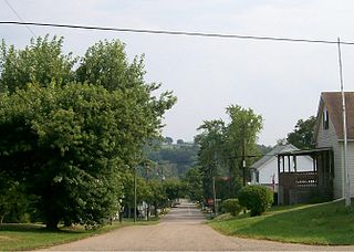
English: The Belmont Historic District as viewed from SR 147 |
| Dat | (UTC) |
| Sous | Travay pèsonèl (Texte original : I (Bwsmith84 (talk)) created this work entirely by myself.) |
| Kreyatè | Bwsmith84 (talk) |
| Pèmisyon : (Resèvi ak fichye sa a) |
Bwsmith84 sur Wikipedya anglais, en tant que détenteur des droits d’auteur sur cette œuvre, la publie sous la licence suivante : Ce fichier est disponible selon les termes de la licence Creative Commons Attribution 3.0 Non transposée. Rekonèt avèk non otè: Bwsmith84 sur Wikipedya anglais
|
| Position de l'objet | | Voir cet endroit et d’autres images sur : OpenStreetMap |
|---|
Journal des téléversements d’origine
Transféré de en.wikipedia à Commons par Sreejithk2000 utilisant CommonsHelper.
La page de description originale était ici. Tous les noms d'utilisateur qui suivent se rapportent à en.wikipedia.
- 2009-08-28 01:16 Bwsmith84 1340×956× (176613 bytes) {{Information |Description = The Belmont Historic District as viewed from SR 147 |Source = I (~~~) created this work entirely by myself. |Date = ~~~~~ |Author = ~~~ |other_versions = }}
Istorik fichye a
Klike sou yon dat/yon lè pou wè fichye a jan li te ye nan moman sa a.
| Dat ak lè | Minyati | Grandè yo | Itilizatè | Komantè | |
|---|---|---|---|---|---|
| Kounye a | 1 jen 2010 à 09:35 | | 1 340 × 956 (172 kio) | File Upload Bot (Magnus Manske) | {{BotMoveToCommons|en.wikipedia|year={{subst:CURRENTYEAR}}|month={{subst:CURRENTMONTHNAME}}|day={{subst:CURRENTDAY}}}} {{Information |Description={{en|The Belmont Historic District as viewed from SR 147}} |Source=Transferred from [http://en.wikipedia.org |
Itilizasyon fichye sa a
paj sa a itilize fichye sa a:
Itilizasyon global fichye a
Wiki sa a yo sèvi ak fichye sa a:
- Itilizasyon sou ar.wikipedia.org
- Itilizasyon sou ca.wikipedia.org
- Itilizasyon sou ceb.wikipedia.org
- Itilizasyon sou cy.wikipedia.org
- Itilizasyon sou en.wikipedia.org
- Itilizasyon sou es.wikipedia.org
- Itilizasyon sou eu.wikipedia.org
- Itilizasyon sou fr.wikipedia.org
- Itilizasyon sou it.wikipedia.org
- Itilizasyon sou lld.wikipedia.org
- Itilizasyon sou pl.wikipedia.org
- Itilizasyon sou pt.wikipedia.org
- Itilizasyon sou sr.wikipedia.org
- Itilizasyon sou uk.wikipedia.org
- Itilizasyon sou vi.wikipedia.org
- Itilizasyon sou www.wikidata.org
- Itilizasyon sou zh-min-nan.wikipedia.org