
Fichye:Map of Bengal.svg

Taille de cet aperçu PNG pour ce fichier SVG : 656 × 599 piksèl. Lòt rezolisyon yo: 263 × 240 piksèl | 526 × 480 piksèl | 841 × 768 piksèl | 1 121 × 1 024 piksèl | 2 242 × 2 048 piksèl | 1 835 × 1 676 piksèl.
Fichye orijinal (Fichye SVG, rezolisyon de 1 835 × 1 676 piksèl, gwosè fichye : 1,32 Mio)
Rezime
| Deskripsyon |
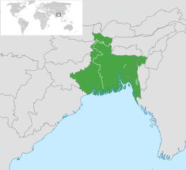
English: Map of Bengal. The region is today divided between East Bengal (Bangladesh) and West Bengal. Also showing the state of Tripura and the three districts of Cachar, Hailakandi and Karimganj; part of Barak Valley in Assam, India. Svenska: Karta av Bengal, delad mellan östra och västra. Staten Tripura och distrikten Hailakandi och Karimganj i södra Assam visas också. বাংলা: বাংলার মানচিত্র, পূর্ব ও পশ্চিমের মধ্যে বিভক্ত করা। মানচিত্রে চিহ্নিত রয়েছে বাংলাদেশের পূর্বে অবস্থিত বাংলাভাষী ভারতীয় রাজ্য ত্রিপুরা সহ আসাম রাজ্যের বরাক উপত্যকার তিনটি জেলা কাছাড়, হাইলাকান্দি এবং করিমগঞ্জ। |
| Dat | |
| Sous |
|
| Kreyatè | Goran tek-en |
| SVG information |

.svg)

Kondisyon itlizasyon
Ce fichier est sous la licence Creative Commons Attribution – Partage dans les Mêmes Conditions 4.0 International.
Rekonèt avèk non otè: Goran tek-en
- Ou gen dwa:
- pou pataje – pou kopye, distribiye epi difize ouvraj la
- pou remiks – pou adapte ouvraj la
- Selon kondisyon sa a yo:
- Rekonèt avèk non otè – Ou dwe bay enfòmasyon apwopriye sou otè a, bay yon lyen pou lisans lan, epi endike si te gen chanjman ki fèt. Ou ka fè sa nan nenpòt fason rezonab, men okenn fason ki sijere ke otè a soutni oswa apwouve itilizasyon ou an.
- Enfòmasyon sa yo ka pataje – Si ou fè rekopye, transfòme, oswa baze sou materyèl sa, ou dwe distribye kontribisyon ou anba menm oswa yon lisans konpatib avèk orijinal la.
Istorik fichye a
Klike sou yon dat/yon lè pou wè fichye a jan li te ye nan moman sa a.
| Dat ak lè | Minyati | Grandè yo | Itilizatè | Komantè | |
|---|---|---|---|---|---|
| Kounye a | 2 novanm 2022 à 10:03 | | 1 835 × 1 676 (1,32 Mio) | MS Sakib | Reverted to version as of 18:02, 10 March 2022 (UTC) (tripura and barak area are included in bengal region!) |
| 4 oktòb 2022 à 05:28 |  | 1 835 × 1 676 (1,31 Mio) | Msasag | Reverted to version as of 16:42, 4 October 2016 (UTC) | |
| 10 mas 2022 à 18:02 |  | 1 835 × 1 676 (1,32 Mio) | MS Sakib | Barak Valley area fixed | |
| 12 novanm 2017 à 11:25 |  | 1 835 × 1 676 (1,32 Mio) | Mouryan | =={{int:filedesc}}== {{Information |description={{en|1=Map of Bengal, divided between east and west.}}{{sv|1=Karta av Bengal, delad mellan östra och västra.}}{{bn|1=বাংলার মানচিত্র, পূর্ব ও পশ্চিম... | |
| 4 oktòb 2016 à 16:42 |  | 1 835 × 1 676 (1,31 Mio) | BurritoBazooka | fix minimap bg turning up transparent in thumbnail? | |
| 4 oktòb 2016 à 16:40 |  | 1 835 × 1 676 (1,31 Mio) | BurritoBazooka | paste File:BlankMap-World gray.svg in again for minimap, this time with Alaska and Lesotho. | |
| 1 desanm 2013 à 17:13 |  | 1 835 × 1 676 (1,19 Mio) | Goran tek-en | Enlarged map ~~~~ | |
| 30 novanm 2013 à 17:53 |  | 1 836 × 1 679 (1,2 Mio) | Goran tek-en | User created page with UploadWizard |
Itilizasyon fichye sa a
paj sa a itilize fichye sa a:
Itilizasyon global fichye a
Wiki sa a yo sèvi ak fichye sa a:
- Itilizasyon sou af.wikipedia.org
- Itilizasyon sou ang.wikipedia.org
- Itilizasyon sou ar.wikipedia.org
- Itilizasyon sou ast.wikipedia.org
- Itilizasyon sou as.wikipedia.org
- Itilizasyon sou azb.wikipedia.org
- Itilizasyon sou az.wikipedia.org
- Itilizasyon sou az.wikiquote.org
- Itilizasyon sou be.wikipedia.org
- Itilizasyon sou bg.wikipedia.org
- Itilizasyon sou bn.wikipedia.org
- টেমপ্লেট:ব্যবহারকারী/বাঙালি
- বঙ্গ
- ব্যবহারকারী:Snthakur
- ব্যবহারকারী:Wiki naogaon
- বঙ্গভঙ্গ (১৯৪৭)
- ব্যবহারকারী:Ali Haidar Khan
- ব্যবহারকারী:Tanveer.nonstop
- ব্যবহারকারী:Faysal
- ব্যবহারকারী:Jonoikobangali
- ব্যবহারকারী:Jayantanth/Userboxes
- ব্যবহারকারী:Yahia.barie
- ব্যবহারকারী:Tarunno
- ব্যবহারকারী:Ikfaisal
- প্রবেশদ্বার:বাংলাদেশ
- ব্যবহারকারী:Pasaban
- ব্যবহারকারী:Wildscop
- ব্যবহারকারী:Rezowan
- ব্যবহারকারী:ছেঁড়াবাকল
- ব্যবহারকারী:DesiNinja
- ব্যবহারকারী:Hemayet
- ব্যবহারকারী:Hemayetfaridpur
- ব্যবহারকারী:004satcho
- ব্যবহারকারী:Babaidmun
- ব্যবহারকারী:Bodhisattwa
- ব্যবহারকারী:Akramul Hoque Samim
- ব্যবহারকারী:শাহনেওয়াজ শুভ
- ব্যবহারকারী:Muhammad Tasbir Iftekhar
- ব্যবহারকারী:Mohd. Toukir Hamid
- ব্যবহারকারী:ইউক্লিড রনি
- ব্যবহারকারী:Sukanta Sarkar
- ব্যবহারকারী:Ashiq Shawon
- ব্যবহারকারী:Asaduzzamana
- ব্যবহারকারী:Akash Islam
- ব্যবহারকারী:Sabarni sarker
- ব্যবহারকারী:হাসান মাহমুদ
- ব্যবহারকারী:Md.Faysal Alam Riyad
Gade plis itilizasyon global fichye sa a.