Aller au contenu

Fichye:Africa-countries-central.png

Le contenu de la page n’est pas pris en charge dans d’autres langues.
Depi Wikipedya, ansiklopedi lib

Africa-countries-central.png (360 × 392 piksèl, gwosè fichye a : 10 kio, tip MIME li ye : image/png)

Fichye sa a sòti nan Wikimedia Commons e ka sèvi nan lòt pwojè. Desktripsyon ki sou paj li file description page ekri anba a.

Une version vectorielle de cette image existe, dans le format « SVG ». Si elle n’est pas inférieure, elle devrait être utilisée à la place de la présente version pour des affichages en plus grandes dimensions ou nécessitant une meilleure résolution.

File:Africa-countries-central.png → File:Africa-countries-central.svg

Pour plus d’informations sur les images vectorielles, consultez la page de transition de Commons vers le format SVG.
Voir aussi les informations à propos de la manière dont le logiciel MediaWiki gère les images au format SVG.

Dans les autres langues
Alemannisch  العربية  беларуская (тарашкевіца)  български  বাংলা  català  нохчийн  čeština  dansk  Deutsch  Ελληνικά  English  British English  Esperanto  español  eesti  euskara  فارسی  suomi  français  Frysk  galego  Alemannisch  עברית  hrvatski  magyar  հայերեն  Bahasa Indonesia  Ido  italiano  日本語  ქართული  한국어  lietuvių  македонски  മലയാളം  Bahasa Melayu  norsk bokmål  Plattdüütsch  Nederlands  norsk nynorsk  norsk  occitan  polski  prūsiskan  português  português do Brasil  română  русский  sicilianu  Scots  slovenčina  slovenščina  српски / srpski  svenska  தமிழ்  ไทย  Türkçe  татарча / tatarça  українська  vèneto  Tiếng Việt  中文  中文(中国大陆)  中文(简体)  中文(繁體)  中文(马来西亚)  中文(新加坡)  中文(臺灣)  中文(臺灣)  +/−
Nouvelle image SVG

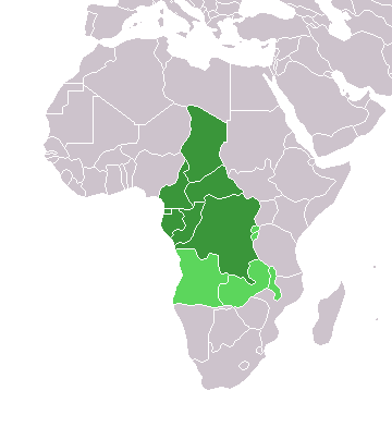
Map of countries in Central Africa.

This map was made by w:User:Joy and originally uploaded to the English Wikipedia as Africa-central-countries.png at 01:32, 28 March 2004. It is a modification of Image:BlankMap-World.png.


GNU head Ou bay pèmisyon pou kopye, distribye ak/oswa modifye dokiman sa a dapre kondisyon GNU Free Documentation License, Vèsyon. 1.2 oswa nenpòt vèsyon ki pibliye pita pa Free Software Foundation; san okenn Seksyon ki pa ka chanje, pa gen okenn Tèks ak premye paj kouvèti, epi pa gen okenn Tèks Denyè-Kouvèti. Gen yon kopi lisans lan nan seksyon ki rele GNU Free Documentation License.
w:fr:Creative Commons
Rekonèt avèk non otè Enfòmasyon sa yo ka pataje
Fichye sa a distribiye selon lisans Creative Commons.
Ou gen dwa:
  • pou pataje – pou kopye, distribiye epi difize ouvraj la
  • pou remiks – pou adapte ouvraj la
Selon kondisyon sa a yo:
  • Rekonèt avèk non otè – Ou dwe bay enfòmasyon apwopriye sou otè a, bay yon lyen pou lisans lan, epi endike si te gen chanjman ki fèt. Ou ka fè sa nan nenpòt fason rezonab, men okenn fason ki sijere ke otè a soutni oswa apwouve itilizasyon ou an.
  • Enfòmasyon sa yo ka pataje – Si ou fè rekopye, transfòme, oswa baze sou materyèl sa, ou dwe distribye kontribisyon ou anba menm oswa yon lisans konpatib avèk orijinal la.
Ce bandeau de licence a été ajouté à ce fichier dans le cadre de la procédure de mise à jour des licences des images sous GFDL.

Légendes

Ajoutez en une ligne la description de ce que représente ce fichier

Éléments décrits dans ce fichier

penn

type MIME français

image/png

23ae13e7f16955c1a313f838e05babd7114b4119

10 309 octet

392 pixel

360 pixel

Istorik fichye a

Klike sou yon dat/yon lè pou wè fichye a jan li te ye nan moman sa a.

Dat ak lèMinyatiGrandè yoItilizatèKomantè
Kounye a17 mas 2018 à 18:21Minyati pou vèsyon 17 mas 2018 à 18:21360 × 392 (10 kio)MaphobbyistMontenegro border
13 janvye 2014 à 18:06Minyati pou vèsyon 13 janvye 2014 à 18:06360 × 392 (10 kio)VVVFSome corrections
9 jiyè 2011 à 19:52Minyati pou vèsyon 9 jiyè 2011 à 19:52360 × 392 (13 kio)MaphobbyistSouth Sudan has become independent on July 9, 2011. Sudan and South Sudan are shown with the new international border between them.
5 me 2006 à 11:10Minyati pou vèsyon 5 me 2006 à 11:10360 × 392 (4 kio)Hautalaoptimized with png
29 avril 2005 à 18:30Minyati pou vèsyon 29 avril 2005 à 18:30360 × 392 (14 kio)ChongDaefrom en:Image:Africa-countries-central.png {{GFDL}} Category:Maps of Africa

paj sa a itilize fichye sa a:

Itilizasyon global fichye a

Wiki sa a yo sèvi ak fichye sa a:

Gade plis itilizasyon global fichye sa a.

Metadone