
Fichye:Trinity-Old-Red-Schoolhouse.jpg
Pa genyen rezolisyon ki pi wo ki disponib.
Trinity-Old-Red-Schoolhouse.jpg (770 × 470 piksèl, gwosè fichye a : 61 kio, tip MIME li ye : image/jpeg)
|
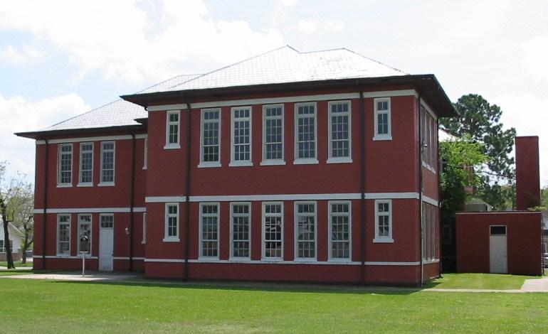
Ceci est une photographie d’un monument référencé dans le National Register of Historic Places des États-Unis sous le numéro 5000865. |
Rezime
| Deskripsyon |
English: Old Red Schoolhouse. Trinity's first schoolhouse was a one-room log structure built in 1872 near Cedar Grove Cemetery. A two-story frame schoolhouse that stood on this site from 1897 to 1911 was moved several blocks northwest to serve African American students. Under Supt. J. Woolam Bright, construction of a new brick building began here in 1911, and after many delays it opened by 1915. The Prairie Style, T-Plan building housed all grade levels until completion of an adjacent High School in 1928. "Old Red" served as a schoolhouse for 80 years. When it was slated for demolition in the 1990s, concerned citizens and former students worked with the School District to preserve the historic building for continued use. Recorded Texas Historic Landmark - 2004. Listed in the National Register of Historic Places by the United States Department of the Interior. |
| Dat | |
| Sous | Own work by uploader Steven Driskell. |
| Kreyatè | Steven L. Driskell (SDriskell) |
| Position de l'objet | | Voir cet endroit et d’autres images sur : OpenStreetMap |
|---|
Kondisyon itlizasyon
Moi, en tant que détenteur des droits d’auteur sur cette œuvre, je la publie sous les licences suivantes :
Fichye sa a distribiye selon lisans Creative Commons.
- Ou gen dwa:
- pou pataje – pou kopye, distribiye epi difize ouvraj la
- pou remiks – pou adapte ouvraj la
- Selon kondisyon sa a yo:
- Rekonèt avèk non otè – Ou dwe bay enfòmasyon apwopriye sou otè a, bay yon lyen pou lisans lan, epi endike si te gen chanjman ki fèt. Ou ka fè sa nan nenpòt fason rezonab, men okenn fason ki sijere ke otè a soutni oswa apwouve itilizasyon ou an.
- Enfòmasyon sa yo ka pataje – Si ou fè rekopye, transfòme, oswa baze sou materyèl sa, ou dwe distribye kontribisyon ou anba menm oswa yon lisans konpatib avèk orijinal la.

|
Ou bay pèmisyon pou kopye, distribye ak/oswa modifye dokiman sa a dapre kondisyon GNU Free Documentation License, Vèsyon. 1.2 oswa nenpòt vèsyon ki pibliye pita pa Free Software Foundation; san okenn Seksyon ki pa ka chanje, pa gen okenn Tèks ak premye paj kouvèti, epi pa gen okenn Tèks Denyè-Kouvèti. Gen yon kopi lisans lan nan seksyon ki rele GNU Free Documentation License. |
Chwazi lisans ou vle a.
Istorik fichye a
Klike sou yon dat/yon lè pou wè fichye a jan li te ye nan moman sa a.
| Dat ak lè | Minyati | Grandè yo | Itilizatè | Komantè | |
|---|---|---|---|---|---|
| Kounye a | 24 mas 2009 à 20:07 | | 770 × 470 (61 kio) | SDriskell | {{Information |Description={{en|1=Old Red Schoolhouse. Trinity's first schoolhouse was a one-room log structure built in 1872 near Cedar Grove Cemetery. A two-story frame schoolhouse that stood on this site from 1897 to 1911 was moved several blocks nor |
Itilizasyon fichye sa a
paj sa a itilize fichye sa a:
Itilizasyon global fichye a
Wiki sa a yo sèvi ak fichye sa a:
- Itilizasyon sou ar.wikipedia.org
- Itilizasyon sou arz.wikipedia.org
- Itilizasyon sou ceb.wikipedia.org
- Itilizasyon sou ce.wikipedia.org
- Itilizasyon sou cy.wikipedia.org
- Itilizasyon sou de.wikipedia.org
- Itilizasyon sou en.wikipedia.org
- Itilizasyon sou es.wikipedia.org
- Itilizasyon sou eu.wikipedia.org
- Itilizasyon sou hu.wikipedia.org
- Itilizasyon sou it.wikipedia.org
- Itilizasyon sou lld.wikipedia.org
- Itilizasyon sou no.wikipedia.org
- Itilizasyon sou pl.wikipedia.org
- Itilizasyon sou pt.wikipedia.org
- Itilizasyon sou sr.wikipedia.org
- Itilizasyon sou sv.wikipedia.org
- Itilizasyon sou tt.wikipedia.org
- Itilizasyon sou uz.wikipedia.org
- Itilizasyon sou vi.wikipedia.org
- Itilizasyon sou www.wikidata.org
- Itilizasyon sou zh-min-nan.wikipedia.org