Fichye:Soldiers-Home-Lincoln-Cottage.jpg

Le contenu de la page n’est pas pris en charge dans d’autres langues.
Depi Wikipedya, ansiklopedi lib

Fichye orijinal(798 × 678 piksèl, gwosè fichye a : 152 kio, tip MIME li ye : image/jpeg)

Fichye sa a sòti nan Wikimedia Commons e ka sèvi nan lòt pwojè. Desktripsyon ki sou paj li file description page ekri anba a.

Ceci est une photographie d’un monument référencé dans le National Register of Historic Places des États-Unis sous le numéro 7001237.

Rezime

Deskripsyon U.S. Soldiers Home, Corn Rigs (Lincoln Cottage), Rock Creek Church Road & Upshur Street Northwest, Washington, D.C. Main façade, oblique view. Now the centerpiece of President Lincoln and Soldiers' Home National Monument. Approximate coordinates: 38°56′30″N 77°0′42″W / 38.9417°N 77.01167°W / 38.9417; -77.01167.
Dat
Sous
Cette image est disponible sur la Prints and Photographs division de la Bibliothèque du Congrès des États-Unis sous le numéro d’identification hhh.dc0445.
Ce bandeau n’indique rien sur le statut de l’œuvre au regard du droit d'auteur. Un bandeau de droit d’auteur est requis. Voir Commons:À propos des licences pour plus d’informations.

العربية  беларуская (тарашкевіца)  বাংলা  čeština  Deutsch  English  español  فارسی  suomi  français  galego  עברית  magyar  Bahasa Indonesia  italiano  日本語  lietuvių  македонски  മലയാളം  Nederlands  polski  português  português do Brasil  română  русский  sicilianu  slovenčina  slovenščina  Türkçe  українська  简体中文  繁體中文  +/−

Kreyatè
Jack Boucher  (1931–2012)  wikidata:Q6111338
 
Autres noms
Jack E. Boucher; Jack Edward Boucher
Description photographe ak photographe d'architecture américain
HABS, HAER and HALS photographer, National Park Service
Date de naissance / décès 4 septanm 1931 Éditer sur Wikidata 2 septanm 2012 Éditer sur Wikidata
Lieu de naissance / décès Buffalo, New York Holy Cross Hospital
Période d’activité de 1949 à 2009
Lieu de travail
Autorité
creator QS:P170,Q6111338
Pèmisyon :
(Resèvi ak fichye sa a)
This file comes from the Historic American Buildings Survey (HABS), Historic American Engineering Record (HAER) or Historic American Landscapes Survey (HALS). These are programs of the National Park Service established for the purpose of documenting historic places. Records consist of measured drawings, archival photographs, and written reports.


When reusing please credit: Library of Congress, Prints & Photographs Division, DC,WASH,534D-4
Ce bandeau n’indique rien sur le statut de l’œuvre au regard du droit d'auteur. Un bandeau de droit d’auteur est requis. Voir Commons:À propos des licences pour plus d’informations.

Public domain This image or media file contains material based on a work of a National Park Service employee, created as part of that person's official duties. As a work of the U.S. federal government, such work is in the public domain in the United States. See the NPS website and NPS copyright policy for more information.
Position de l'objet38° 56′ 10,85″ N, 77° 00′ 32,59″ O Kartographer map based on OpenStreetMap.Voir cet endroit et d’autres images sur : OpenStreetMapinfo
Cette image a été retouchée, ce qui signifie qu'elle a été modifiée par ordinateur et est différente de l'image d'origine. Liste des modifications : cropped.

Légendes

Ajoutez en une ligne la description de ce que représente ce fichier

Éléments décrits dans ce fichier

dépeint français

fevriye 1975

38°56'10.849"N, 77°0'32.591"W

Istorik fichye a

Klike sou yon dat/yon lè pou wè fichye a jan li te ye nan moman sa a.

Dat ak lèMinyatiGrandè yoItilizatèKomantè
Kounye a26 avril 2006 à 18:28Minyati pou vèsyon 26 avril 2006 à 18:28798 × 678 (152 kio)Eoghanacht
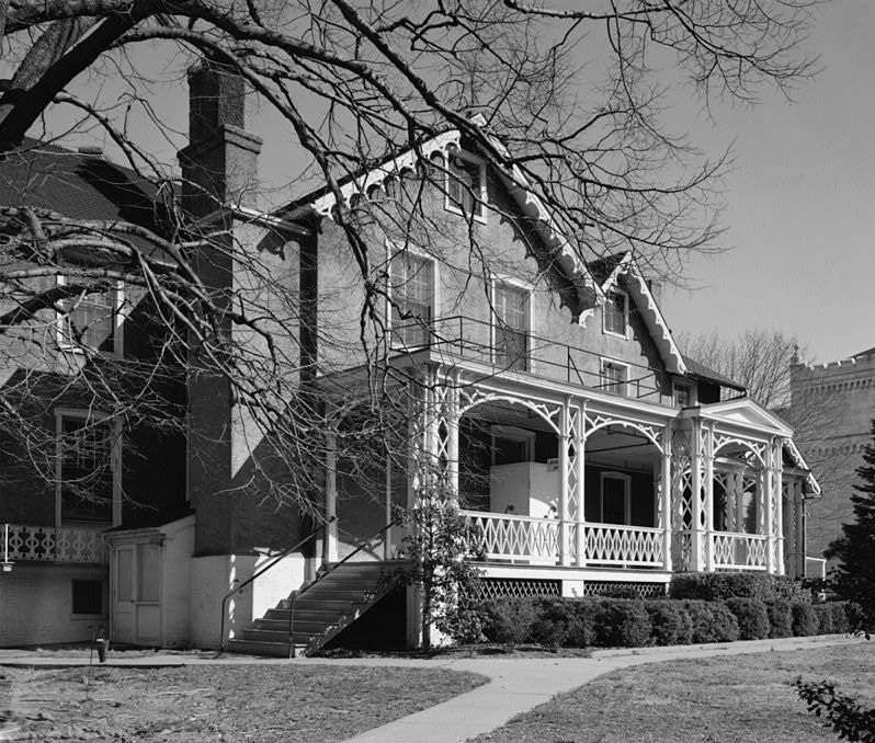
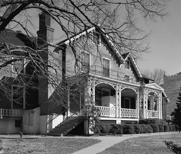
{{Information| |Description=U.S. Soldiers Home, Corn Rigs (Lincoln Cottage), Rock Creek Church Road & Upshur Street Northwest, Washington, D.C. Main façade, oblique view. Now the centerpiece of [w:President Lincoln and Soldiers' Home National Monument|

paj sa a itilize fichye sa a:

Itilizasyon global fichye a