
Fichye:SaylorvilleMines.png
Pa genyen rezolisyon ki pi wo ki disponib.
SaylorvilleMines.png (586 × 530 piksèl, gwosè fichye a : 65 kio, tip MIME li ye : image/png)
Rezime
| Deskripsyon |
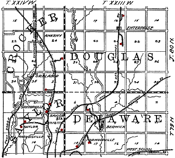
English: Original caption: "Figure 35. Map showing location of principal Polk County mines outside of the Des Moines district." en:Saylorville, Iowa is in the lower left quadrant. Mines have been tinted red by the uploader. The railroads shown on the map are: en:Fort Dodge, Des Moines and Southern Railroad, en:Chicago and North Western Railroad, en:St. Paul and Des Moines Railroad, en:Chicago Great Western Railroad and an unidentified en:Interurban. |
| Dat | |
| Sous | The Coal Deposits of Iowa, Chapter I of Iowa Geological Survey Annual Report, 1908 |
| Kreyatè | Henry Hinds |
| Lieu de la prise de vue | | Voir cet endroit et d’autres images sur : OpenStreetMap |
|---|
Kondisyon itlizasyon
Ce document est dans le domaine public aux États-Unis. Ceci s'applique aux travaux des États-Unis où le copyright a expiré, souvent parce que sa première publication s'est produite avant le 1er janvier 1929. Voir cette page pour davantage d'explication.
|
 | |
 |
Cette image peut ne pas être dans le domaine public en dehors des États-Unis (ceci s'applique particulièrement au Canada, en Chine (pas Hong Kong, Macao, ni Taïwan), en Allemagne ou en Suisse). Le créateur et l'année de la publication sont l'information essentielle et doivent être fournis.
|
Istorik fichye a
Klike sou yon dat/yon lè pou wè fichye a jan li te ye nan moman sa a.
| Dat ak lè | Minyati | Grandè yo | Itilizatè | Komantè | |
|---|---|---|---|---|---|
| Kounye a | 19 out 2009 à 15:50 | | 586 × 530 (65 kio) | Douglas W. Jones | {{Information |Description={{en|1=Original caption: "Figure 35. Map showing location of principal Polk County mines outside of the Des Moines district." en:Saylorville, Iowa is in the lower left quadrant. Mines have been tinted red by the uploader |
Itilizasyon fichye sa a
paj sa a itilize fichye sa a:
Itilizasyon global fichye a
Wiki sa a yo sèvi ak fichye sa a:
- Itilizasyon sou en.wikipedia.org
- Itilizasyon sou es.wikipedia.org
- Itilizasyon sou id.wikipedia.org
- Itilizasyon sou ro.wikipedia.org
- Itilizasyon sou www.wikidata.org