
Fichye:Endicott-Johnson Workers Arch, approximately 250' east of intersection of Bridge, Endicott (Broome County, New York).jpg
Pa genyen rezolisyon ki pi wo ki disponib.
Endicott-Johnson_Workers_Arch,_approximately_250'_east_of_intersection_of_Bridge,_Endicott_(Broome_County,_New_York).jpg (559 × 406 piksèl, gwosè fichye a : 71 kio, tip MIME li ye : image/jpeg)
|
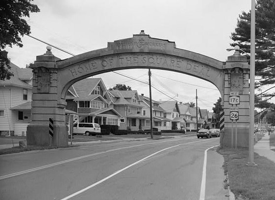
Ceci est une photographie d’un monument référencé dans le National Register of Historic Places des États-Unis sous le numéro 1000171. |
| Deskripsyon |
English: Endicott-Johnson Workers Arch, Approximately 250' east of intersection of Bridge , Endicott (Broome County, New York)
cropped
|
|||||||||
| Dat | Date inconnue | |||||||||
| Sous | http://memory.loc.gov/cgi-bin/displayPhoto.pl?path=/pnp/habshaer/ny/ny1700/ny1738/photos&topImages=350883pr.jpg&topLinks=350883pv.jpg,350883pu.tif&title=HABS%20NY,4-ENDI,1-4&displayProfile=0 | |||||||||
| Kreyatè | Auteur inconnu |

.jpg)
.jpg¶ms=042.111389_N_-075.946111_E_globe:Earth_class:object_region:US_type:landmark_scale:1500_&language=ht)
Istorik fichye a
Klike sou yon dat/yon lè pou wè fichye a jan li te ye nan moman sa a.
| Dat ak lè | Minyati | Grandè yo | Itilizatè | Komantè | |
|---|---|---|---|---|---|
| Kounye a | 1 out 2009 à 18:56 | | 559 × 406 (71 kio) | KudzuVine | {{Information |Description={{en|1=Endicott-Johnson Workers Arch, Approximately 250' east of intersection of Bridge , Endicott (Broome County, New York) cropped {{PD-USGov-Interior-HABS|NY,4-ENDI,1-4}}}} |Source=http://memory.loc.gov/cgi-bin/displayPhoto. |
Itilizasyon fichye sa a
paj sa a itilize fichye sa a:
Itilizasyon global fichye a
Wiki sa a yo sèvi ak fichye sa a:
- Itilizasyon sou azb.wikipedia.org
- Itilizasyon sou ce.wikipedia.org
- Itilizasyon sou de.wikipedia.org
- Itilizasyon sou en.wikipedia.org
- Itilizasyon sou es.wikipedia.org
- Itilizasyon sou eu.wikipedia.org
- Itilizasyon sou fr.wikipedia.org
- Itilizasyon sou it.wikipedia.org
- Itilizasyon sou pl.wikipedia.org
- Itilizasyon sou tt.wikipedia.org
- Itilizasyon sou uk.wikipedia.org
- Itilizasyon sou ur.wikipedia.org
- Itilizasyon sou uz.wikipedia.org
- Itilizasyon sou www.wikidata.org
- Itilizasyon sou zh.wikipedia.org
.jpg)