
Fichye:Bridge in Westover Borough.jpg

Dimansyon previzyalizasyon sa a : 723 × 600 piksèl. Lòt rezolisyon yo: 289 × 240 piksèl | 579 × 480 piksèl | 764 × 634 piksèl.
Fichye orijinal (764 × 634 piksèl, gwosè fichye a : 46 kio, tip MIME li ye : image/jpeg)
|
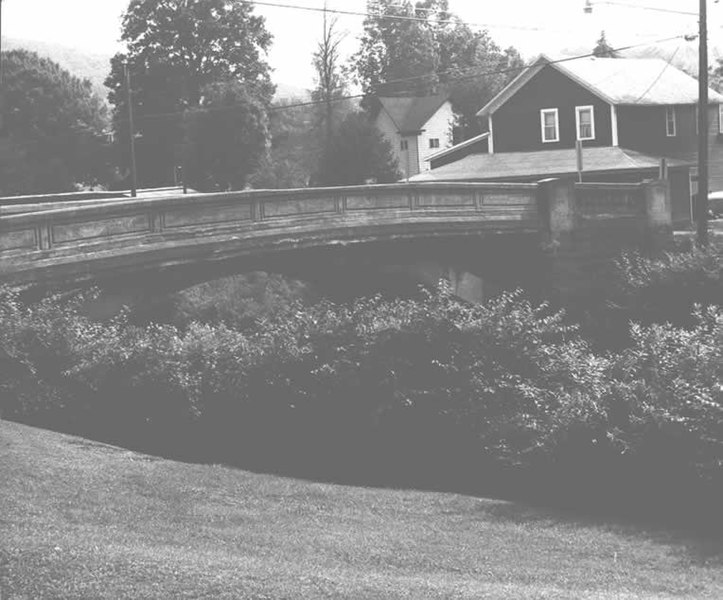
Ceci est une photographie d’un monument référencé dans le National Register of Historic Places des États-Unis sous le numéro 88000736. |
| Lieu de la prise de vue | | Voir cet endroit et d’autres images sur : OpenStreetMap |
|---|
| Deskripsyon |
English: Side of the Bridge in Westover Borough, which carries Legislative Route 17003/Township Route 185 over Chest Creek in Westover, Pennsylvania, United States. Built in 1917, this open spandrel concrete arch bridge is listed on the National Register of Historic Places. |
|||
| Dat | ||||
| Sous | "Bridge in Westover Borough" (National Register of Historic Places form). National Park Service (June 22, 1988). Photo from http://www.arch.state.pa.us, searchable database, at http://www.arch.state.pa.us/images/hires/H000121_01B.jpg | |||
| Kreyatè | PennDOT | |||
| Pèmisyon : (Resèvi ak fichye sa a) |
|

Istorik fichye a
Klike sou yon dat/yon lè pou wè fichye a jan li te ye nan moman sa a.
| Dat ak lè | Minyati | Grandè yo | Itilizatè | Komantè | |
|---|---|---|---|---|---|
| Kounye a | 21 desanm 2009 à 04:10 | | 764 × 634 (46 kio) | Nyttend | {{Location|40|45|9|N|78|40|3|W}} {{Information |Description={{en|Side of the {{w|Bridge in Westover Borough}}, which carries Legislative Route 17003/Township Route 185 over {{w|Chest Creek}} in {{w|Westover, Pennsylvania|Westover}}, {{w|Pennsylvania}}, {{ |
Itilizasyon fichye sa a
paj sa a itilize fichye sa a:
Itilizasyon global fichye a
Wiki sa a yo sèvi ak fichye sa a:
- Itilizasyon sou ar.wikipedia.org
- Itilizasyon sou azb.wikipedia.org
- Itilizasyon sou ca.wikipedia.org
- Itilizasyon sou ceb.wikipedia.org
- Itilizasyon sou ce.wikipedia.org
- Itilizasyon sou cy.wikipedia.org
- Itilizasyon sou en.wikipedia.org
- Itilizasyon sou es.wikipedia.org
- Itilizasyon sou eu.wikipedia.org
- Itilizasyon sou fr.wikipedia.org
- Itilizasyon sou it.wikipedia.org
- Itilizasyon sou lld.wikipedia.org
- Itilizasyon sou pt.wikipedia.org
- Itilizasyon sou sr.wikipedia.org
- Itilizasyon sou tl.wikipedia.org
- Itilizasyon sou tt.wikipedia.org
- Itilizasyon sou uk.wikipedia.org
- Itilizasyon sou uz.wikipedia.org
- Itilizasyon sou vi.wikipedia.org
- Itilizasyon sou www.wikidata.org
- Itilizasyon sou zh-min-nan.wikipedia.org