
Fichye:Abu Dhabi from Space-ISS006-E-32079-March 2003.JPG

Dimansyon previzyalizasyon sa a : 800 × 530 piksèl. Lòt rezolisyon yo: 320 × 212 piksèl | 640 × 424 piksèl | 1 024 × 678 piksèl | 1 280 × 847 piksèl | 3 029 × 2 005 piksèl.
Fichye orijinal (3 029 × 2 005 piksèl, gwosè fichye a : 536 kio, tip MIME li ye : image/jpeg)
Rezime
| Deskripsyon |
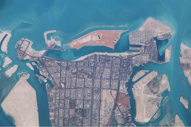
English: Satellite picture of the island of Abu Dhabi.
Picture taken by International Space Station in March 2003 during ISS Expedition 6 |
| Dat | |
| Sous | JSC Gateway to Astronaut Photography of Earth |
| Kreyatè | Earth Science and Remote Sensing Unit, NASA Johnson Space Center |
| Sun Azimuth | 200° |
| Sun Elevatation | 55° |
| Altitude | 211 nautical miles (391 km) |
| Mission | ISS006 |
| Roll | E |
| Frame | 32079 |
| Camera | Kodak DCS760c |
| Camera Tilt | 29° |
| Focal length | 800 mm |
| Lieu de la prise de vue | | Voir cet endroit et d’autres images sur : OpenStreetMap |
|---|
| Position de l'objet | | Voir cet endroit et d’autres images sur : OpenStreetMap |
|---|
Cette image ou vidéo a été cataloguée par le Johnson Space Center de la National Aeronautics and Space Administration (NASA) des États-Unis sous Photo ID : ISS043-E-78052.Ce bandeau n’indique rien sur le statut de l’œuvre au regard du droit d'auteur. Un bandeau de droit d’auteur est requis. Voir Commons:À propos des licences pour plus d’informations. Autres langues :
|
Kondisyon itlizasyon
| Ce fichier provient de la NASA. Sauf exception, les documents créés par la NASA ne sont pas soumis à copyright. Pour plus d'informations, voir la politique de copyright de la NASA. | ||
 |
Attention :
|
Istorik fichye a
Klike sou yon dat/yon lè pou wè fichye a jan li te ye nan moman sa a.
| Dat ak lè | Minyati | Grandè yo | Itilizatè | Komantè | |
|---|---|---|---|---|---|
| Kounye a | 3 fevriye 2005 à 00:58 | | 3 029 × 2 005 (536 kio) | ThorstenS | Satellite picture of island Abu Dhabi |
Itilizasyon fichye sa a
paj sa a itilize fichye sa a:
Itilizasyon global fichye a
Wiki sa a yo sèvi ak fichye sa a:
- Itilizasyon sou ar.wikipedia.org
- Itilizasyon sou arz.wikipedia.org
- Itilizasyon sou ast.wikipedia.org
- Itilizasyon sou bjn.wikipedia.org
- Itilizasyon sou ca.wikipedia.org
- Itilizasyon sou es.wikipedia.org
- Itilizasyon sou eu.wikipedia.org
- Itilizasyon sou fr.wikipedia.org
- Itilizasyon sou hif.wikipedia.org
- Itilizasyon sou id.wikipedia.org
- Itilizasyon sou is.wikipedia.org
- Itilizasyon sou it.wikipedia.org
- Itilizasyon sou jv.wikipedia.org
- Itilizasyon sou mk.wikipedia.org
- Itilizasyon sou ms.wikipedia.org
- Itilizasyon sou pam.wikipedia.org
- Itilizasyon sou pl.wiktionary.org
- Itilizasyon sou roa-tara.wikipedia.org
- Itilizasyon sou simple.wikipedia.org
- Itilizasyon sou sr.wikipedia.org
- Itilizasyon sou sv.wikipedia.org
- Itilizasyon sou sw.wikipedia.org