
Fichye:-IDAHO-L-0011- Teton Dam Flood - Newdale (5811753523).jpg
Fichye orijinal (2 657 × 1 798 piksèl, gwosè fichye a : 510 kio, tip MIME li ye : image/jpeg)
.jpg)
Rezime
| Deskripsyon |
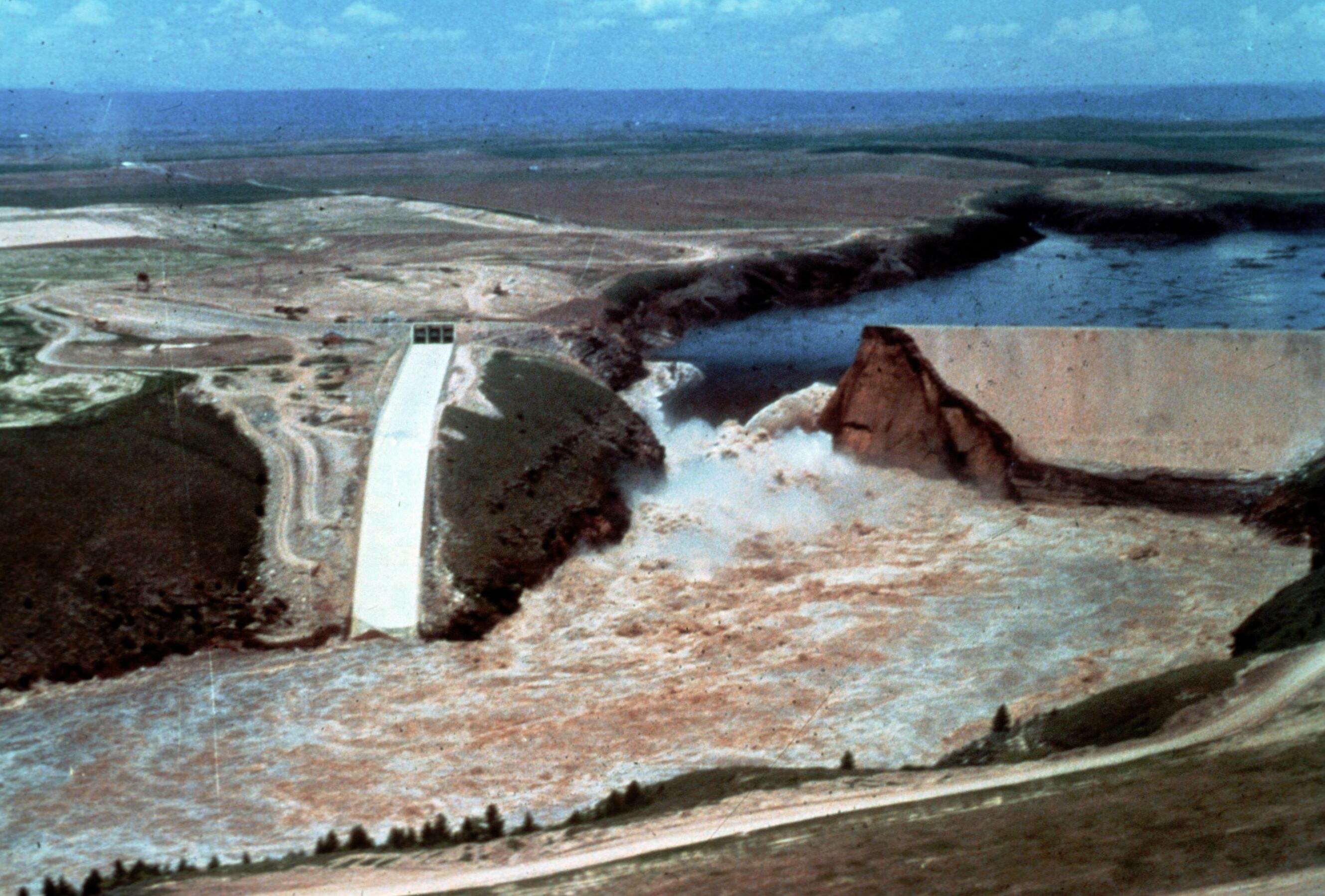
Image Title: Teton Dam Flood - Newdale Date: June 5, 1976 Place: Teton River, Newdale, Idaho Description/Caption: Progressive stages of break in the Dam. Statistics of interest: 80 billion gallons (220,000 acre feet) of water released. Floodwaters' path was seven miles wide in some places (average depth 8-10 feet). 100,000 acres of farmland stripped of topsoil; 13,000 head of livestock killed; 4000 homes, 50 businesses, 3500 farm buildings destroyed. Medium: color transparency Photographer/Maker: Bureau of Reclamation Cite as: ID-L-0011, WaterArchives.org Restrictions: There are no known U.S. copyright restrictions on this image. While the digital image is freely available, it is requested that <a href="http://www.waterarchives.org" target="browser" rel="nofollow">www.waterarchives.org</a> be credited as its source. For higher quality reproductions of the original physical version contact <a href="http://www.waterarchives.org" target="browser" rel="nofollow">www.waterarchives.org</a>, restrictions may apply. |
| Dat | |
| Sous | [IDAHO-L-0011] Teton Dam Flood - Newdale |
| Kreyatè | WaterArchives.org from Las Cruces, New Mexico, United States |
| Lieu de la prise de vue | | Voir cet endroit et d’autres images sur : OpenStreetMap |
|---|
.jpg¶ms=043.910113_N_-111.539983_E_globe:Earth_type:camera_source:Flickr_&language=ht)
Kondisyon itlizasyon
- Ou gen dwa:
- pou pataje – pou kopye, distribiye epi difize ouvraj la
- pou remiks – pou adapte ouvraj la
- Selon kondisyon sa a yo:
- Rekonèt avèk non otè – Ou dwe bay enfòmasyon apwopriye sou otè a, bay yon lyen pou lisans lan, epi endike si te gen chanjman ki fèt. Ou ka fè sa nan nenpòt fason rezonab, men okenn fason ki sijere ke otè a soutni oswa apwouve itilizasyon ou an.
- Enfòmasyon sa yo ka pataje – Si ou fè rekopye, transfòme, oswa baze sou materyèl sa, ou dwe distribye kontribisyon ou anba menm oswa yon lisans konpatib avèk orijinal la.
| Cette image a été originellement postée sur Flickr par waterarchives à l'adresse https://flickr.com/photos/23487245@N08/5811753523. Elle a été passée en revue le 15 jen 2020 par le robot FlickreviewR 2, qui a confirmé qu'elle se trouvait sous licence cc-by-sa-2.0. |
Istorik fichye a
Klike sou yon dat/yon lè pou wè fichye a jan li te ye nan moman sa a.
| Dat ak lè | Minyati | Grandè yo | Itilizatè | Komantè | |
|---|---|---|---|---|---|
| Kounye a | 4 avril 2023 à 15:13 | | 2 657 × 1 798 (510 kio) | Rémih | Cropped 8 % horizontally, 7 % vertically using CropTool with precise mode. |
| 15 jen 2020 à 09:48 |  | 2 882 × 1 940 (548 kio) | Kingofthedead | Transferred from Flickr via #flickr2commons |
Itilizasyon fichye sa a
paj sa a itilize fichye sa a:
Itilizasyon global fichye a
Wiki sa a yo sèvi ak fichye sa a:
- Itilizasyon sou ar.wikipedia.org
- Itilizasyon sou arz.wikipedia.org
- Itilizasyon sou bg.wikipedia.org
- Itilizasyon sou ca.wikipedia.org
- Itilizasyon sou ce.wikipedia.org
- Itilizasyon sou cy.wikipedia.org
- Itilizasyon sou es.wikipedia.org
- Itilizasyon sou eu.wikipedia.org
- Itilizasyon sou fr.wikipedia.org
- Itilizasyon sou it.wikipedia.org
- Itilizasyon sou ky.wikipedia.org
- Itilizasyon sou lld.wikipedia.org
- Itilizasyon sou no.wikipedia.org
- Itilizasyon sou oc.wikipedia.org
- Itilizasyon sou pl.wikipedia.org
- Itilizasyon sou sr.wikipedia.org
- Itilizasyon sou tt.wikipedia.org
- Itilizasyon sou uk.wikipedia.org
- Itilizasyon sou uz.wikipedia.org
- Itilizasyon sou www.wikidata.org
.jpg)